Space Industry and Business News  
The Hills And Valleys Of Earth's Largest Salt Flat

The scientists' most unexpected finding was that the broadest topographic features on the salar correlate well with the increase in the strength of gravity at the surface that results from dense rock buried underneath salar sediments. Just as the ocean surface rises over denser seamounts, the salar surface also rises and falls to reflect the subsurface density variations. This effect has never before been observed on land.
by Staff Writers
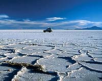
Oxford, UK (SPX) Nov 29, 2007
Using a new twist on standard Global Positioning System (GPS) technology, a team of scientists has found that Earth's largest salt flat is rougher than expected, according to a new report led by Adrian Borsa of Scripps Institution of Oceanography at UC San Diego and published in Geophysical Journal International. Borsa and his team studied the salar de Uyuni in southwestern Bolivia, which is both a popular tourist destination and a potential calibration site for Earth-orbiting scientific instruments.

It had never before been surveyed on this scale using modern techniques. Although the salar appears to be perfectly flat to the eye, by applying an innovative method of error correction to their data, the team was able to identify broad features ranging in height from a few centimeters to half a meter and extending over distances of tens of kilometers or more.

Earlier maps do not show any surface relief on the salar de Uyuni. By mapping the surface to the accuracy of a few centimeters, the research team uncovered previously hidden features -- hills, ridges and valleys -- and opened the salar for use as a ground reference site for highly accurate satellite-based ranging instruments. "We had no idea these features existed," said Dr. Borsa, "but they matter to anyone who uses the salt flat to calibrate satellite altimeters."

The scientists' most unexpected finding was that the broadest topographic features on the salar correlate well with the increase in the strength of gravity at the surface that results from dense rock buried underneath salar sediments. Just as the ocean surface rises over denser seamounts, the salar surface also rises and falls to reflect the subsurface density variations. This effect has never before been observed on land.

Related Links
GPS Applications, Technology and Suppliers


Memory Foam Mattress Review
Newsletters :: SpaceDaily :: SpaceWar :: TerraDaily :: Energy Daily
XML Feeds :: Space News :: Earth News :: War News :: Solar Energy News


EU antitrust regulators to probe GPS devices deal
Brussels (AFP) Nov 28, 2007
EU regulators on Wednesday opened a detailed probe of Dutch technology group TomTom's takeover of Dutch firm Tele Atlas on concerns the deal could stifle competition in the market for hand-held navigation devices.


  • Beyond Books: Virginia Tech Libraries In The Digital Age
  • Bee Strategy Helps Servers Run More Sweetly
  • Electricity Grid Could Become A Type Of Internet
  • Google revs up profits as advertising revenues soar

  • Sea Launch Reschedules The Thuraya-3 Launch Campaign
  • Sea Launch Reschedules The Thuraya-3 Launch Campaign
  • Thuraya-3 Satellite Launch Delayed Again
  • Russia To Launch Manned Spacecraft From New Site In 2018

  • Announcement Of Opportunity For Sounding Rocket And Balloon Flights
  • China to order up to 150 Airbus jets during Sarkozy visit: report
  • Time Magazine Recognizes The X-48B
  • Virgin to offer carbon offsets alongside drinks and perfume

  • Boeing Demonstrates Maturity Of TSAT Encryption System
  • Northrop Grumman Qualifies Extended Data Rate Software For AEHF Military Communications Satellite
  • Lockheed Martin Delivers Key Satellite Hardware For New Military Communications System
  • Boeing Demonstrates FAB-T Multi-terminal Link Capability To USAF

  • 40th Anniversary Of Australia's First Satellite
  • Blue Dye Could Hold The Key To Super Processing Power
  • ESA And Inmarsat Sign Innovative Alphasat Satellite Contract
  • Dude, Big Screen TVs, Flexible Electronics And Surfboards Made From Same New Material

  • Boeing Names Darryl Davis To Lead Advanced Systems For Integrated Defense Systems
  • Northrop Grumman Names John Landon VP Of Missiles, Technology And Space Programs
  • Dr Mary Cleave Appointed To Board Of Directors Of Sigma Space
  • Northrop Grumman Appoints GPS And Military Space VPs

  • China, Brazil give Africa free satellite land images
  • Ministerial Summit On Global Earth Observation System Of Systems
  • NASA-Conceived Map Of Antarctica Lays Ground For New Discoveries
  • Rosetta: Earth's True Colours

  • EU satnav project edges towards launch pad
  • EU antitrust regulators to probe GPS devices deal
  • US plans GPS satellite navigation upgrade to rival EU
  • The Hills And Valleys Of Earth's Largest Salt Flat

  • The content herein, unless otherwise known to be public domain, are Copyright Space.TV Corporation. AFP and UPI Wire Stories are copyright Agence France-Presse and United Press International. ESA Portal Reports are copyright European Space Agency. All NASA sourced material is public domain. Additional copyrights may apply in whole or part to other bona fide parties. Advertising does not imply endorsement, agreement or approval of any opinions, statements or information provided by Space.TV Corp on any Web page published or hosted by Space.TV Corp. Privacy Statement