|
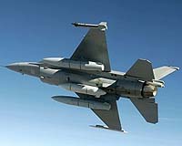
Greenlawn NY (SPX) Nov 30, 2007 BAE Systems has completed in-country commissioning in Oman for a long-range, electro-optical reconnaissance system as part of the F-16 Oman Peace A'sama A'safiya program. The commissioning marks the first fielding and sale of BAE Systems' Airborne Reconnaissance System (ARS) camera. ARS can take pictures day or night at fighter-plane speeds and altitudes from 3,000 to 40,000 feet and at ranges up to 100 nautical miles. It has the largest focal length currently available for tactical reconnaissance missions. "The increased focal length allows military personnel to take clear pictures or collect reconnaissance data from a greater, and therefore safer, distance," said Raymond Fricker, identification and surveillance program manager for BAE Systems in Greenlawn, New York. "This system can cover more area per minute than any other system available today." Performance and aircraft integration testing were completed earlier this year at Edwards Air Force Base, California. ARS met all criteria for aircraft operations, imagery collection, carriage and handling, and safety of flight. The systems were then shipped to Oman for integration into the arsenal of the Royal Air Force of Oman (RAFO). RAFO, U.S. government, and BAE Systems personnel conducted 11 flights in three days with complete data analysis as part of the commissioning effort, enabling the RAFO Reconnaissance Program to become operational four months ahead of schedule. More than 10,000 image frames compressed into 250 gigabytes of digital visible and infrared imagery were collected and viewed on the BAE Systems-supplied ground intelligence processing station. ARS digitally records imagery in the visible and infrared light spectra. The system contains adaptable optics, allowing the collection of imagery in dual fields of view and allowing the sensor to operate with high- and medium-altitude functionality. During all operational modes, recorded imagery is displayed on the aircraft's multi-function display. RAFO also uses the advanced ARS, which provides high-resolution, digital, electro-optical imagery in support of combat operations such as enemy order of battle, targeting, and combat assessment. In peacetime, ARS will give RAFO the ability to closely monitor its borders and surrounding sea areas for activities such as smuggling, illegal immigration, and terrorist activities. Related Links The latest in Military Technology for the 21st century at SpaceWar.com
 East Hartford CT (SPX) Nov 30, 2007
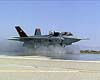
Pratt And Whitney has delivered the first F135 short-takeoff/vertical-landing (STOVL) propulsion system including the Rolls-Royce Lift System to Lockheed Martin in Fort Worth, Texas. The propulsion system will support airframe and engine interface evaluations for the first STOVL flight test aircraft, scheduled for its initial flight in May 2008. Pratt and Whitney is a United Technologies. |
|
| The content herein, unless otherwise known to be public domain, are Copyright Space.TV Corporation. AFP and UPI Wire Stories are copyright Agence France-Presse and United Press International. ESA Portal Reports are copyright European Space Agency. All NASA sourced material is public domain. Additional copyrights may apply in whole or part to other bona fide parties. Advertising does not imply endorsement, agreement or approval of any opinions, statements or information provided by Space.TV Corp on any Web page published or hosted by Space.TV Corp. Privacy Statement |