 |
Hampton VA (SPX) Jan 11, 2011 It's hard to believe that, in this day and age, we don't have a way to measure sea-level air pressure during hurricanes. NASA researchers, however, are working on a system that will improve forecasting of severe ocean weather by doing just that. The device measures sea-level air pressure, a critical component of hurricane formation - and one that has been extremely difficult to capture. The Differential Absorption Barometric Radar (DIABAR) prototype is scheduled to make its second flight early this year. DIABAR remotely senses barometric pressure at sea level, which is important in the prediction and forecasting of severe weather, especially hurricanes, over oceans. But the ability to measure sea-level air pressure is a major missing link in storm observation, says Dr. Bing Lin, an atmospheric scientist at NASA Langley Research Center in Hampton, Va. "Air pressure is a driving force of weather systems, especially under severe weather conditions like hurricanes," he said. "For severe storms, the forecasts of the intensity and track can be significantly improved by pressure measurements."
A Hurricane's Life As air pressure drops and winds sustain at 38 mph or more, the disturbance becomes a tropical depression, then a tropical storm, and finally a hurricane with sustained winds of over 73 mph. Lin hopes eventually to be able to measure sea-level air pressure from aircraft flyovers and space-based satellites. The local coverage provide by flyovers, combined with a broad perspective from space, will provide enough information to significantly improve the ability of forecasters to determine how intense a hurricane is and where it's headed. "Large and frequent sea surface measurements are critically needed," he said. "These measurements cannot be made from buoys and aircraft dropsondes. The only hope is from remote sensing using aircraft, unmanned aerial vehicles, and satellites." An effort to remotely sense barometric pressure at sea-surface level using microwaves was undertaken at NASA's Jet Propulsion Laboratory in Pasadena, Calif., in the 1980s. "JPL has extensive experience on spaceborne microwave sensors," said Lin.
First Flight "We flew it, got the results, and it looks great," said Lin. The next step is testing this year on a blimp called the Bullet Class 580, the world's largest airship. E-Green Technologies Inc. in Alabama makes the aircraft. The 235-foot long, 65-foot diameter lighter-than-air vehicle is designed to fly on algae-based biofuel at speeds up to 74 mph and altitudes up to 20,000 feet. It will be stationed in a hanger at Moffett Federal Airfield at NASA Ames Research Center in California. DIABAR is a partnership between NASA Langley, Old Dominion University in Norfolk, Va., and the State University of New York at Albany.
Share This Article With Planet Earth
Related Links NASA's Hurricane Resource Page Earth Observation News - Suppiliers, Technology and Application
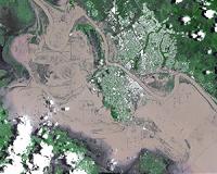 NASA Image Shows La Nina-Caused Woes Down Under
Pasadena CA (JPL) Jan 10, 2011 The current La Nina in the Pacific Ocean, one of the strongest in the past 50 years, continues to exert a powerful influence on weather around the world, affecting rainfall and temperatures in varying ways in different locations. For Australia, La Nina typically means above-average rains, and the current La Nina is no exception. Heavy rains that began in late December led to the cont ... read more |
|
| The content herein, unless otherwise known to be public domain, are Copyright 1995-2010 - SpaceDaily. AFP and UPI Wire Stories are copyright Agence France-Presse and United Press International. ESA Portal Reports are copyright European Space Agency. All NASA sourced material is public domain. Additional copyrights may apply in whole or part to other bona fide parties. Advertising does not imply endorsement,agreement or approval of any opinions, statements or information provided by SpaceDaily on any Web page published or hosted by SpaceDaily. Privacy Statement |


 del.icio.us
 Digg
Digg Reddit
 YahooMyWeb
 Google