Space Industry and Business News  
US giving China satellite images of quake damage: Pentagon

File image of an EO satellite photo supplied by Taiwan and soon to be supplemented with higher resolution images from the US.
by Staff Writers
Washington (AFP) May 19, 2008
The United States is providing China with satellite imagery of reservoirs, roads and bridges damaged in the earthquake that devastated southwestern Sichuan province, the Pentagon said.

The National Geospatial-Intelligence Agency is expected to provide the first of the unclassified imagery on Monday if weather permits, in what officials believed to be an unprecedented step.

"They have asked the United States for some imagery of damaged reservoirs, roads, and bridges and the National Geospatial-Intelligence agency (NGA) is providing resources to give them that type of support," said Pentagon spokesman Bryan Whitman.

China paved the way for the heightened level of cooperation over the weekend by allowing two US Air Force C-17 transport planes to fly in to Changdou, China with food, water, containers, blankets, generators, and various types of hand tools.

An estimated 71,000 people are dead, missing or buried a week after a powerful earthquake struck southwestern China.

A spokesman for the NGA said the agency was providing annotated images and maps to Chinese authorities through diplomatic channels.

"This event appears to be the first time that NGA, or one of its predecessor organizations, has provided unclassified imagery-derived products to the PRC (Peoples Republic of China) in support of disaster relief efforts," said NGA spokesman David Burpee.

But he said unclassified textual reports derived from imagery may have been provided to China before in disaster relief situations.

Related Links
Earth Observation News - Suppiliers, Technology and Application


Memory Foam Mattress Review
Newsletters :: SpaceDaily :: SpaceWar :: TerraDaily :: Energy Daily
XML Feeds :: Space News :: Earth News :: War News :: Solar Energy News


Taiwan shares satellite images with China of quake disaster area
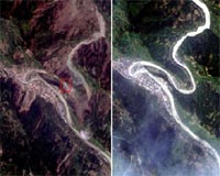
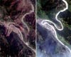
Taipei (AFP) May 15, 2008
Taiwan has provided rival China satellite images showing some areas devastated by the 7.9-magnitude earthquake in the mainland's southwest, officials and academics said Thursday.


  • Icahn moves to replace Yahoo board, restart Microsoft talks
  • Intelsat And Panasonic To Bring Broadband Service To The Skies
  • Google wins from end of Microsoft-Yahoo affair: analysts
  • Microsoft takeover deadline for Yahoo expires without comment

  • Sweden Launches MASER 11 Sounding Rocket
  • Spaceport Kourou Welcomes Fourth Ariane 5 Launch Campaign For 2008
  • Orbital Awarded Contract for Suborbital Launch Vehicle Research by US DoD
  • Arianespace Takes Delivery Of Its Third Ariane 5 In 2008

  • China's new jumbo-jet firm no threat to Airbus, Boeing: state media
  • China unveils new jumbo jet company: report
  • NASA And JAXA To Conduct Joint Research On Sonic Boom Modeling
  • Analysis: Can airplanes go green?

  • Northrop Grumman Begins Installing New Engines On Joint STARS
  • Battlefield Airborne ComNode Enables Real-Time Distribution Of F-22 Data To Legacy Aircraft
  • Lockheed Martin Submits Bid For USAF Space Situational Awareness Program
  • GD Awarded Contract For Next-Gen Cryptographic Technologies

  • US, China Space Debris Still Orbiting Earth
  • Northrop Grumman Resonating Gyro Achieves 10 Million Operating Hours In Space
  • TerraSAR-X And NFIRE Fire Up The Pipe With Laser Data Transfer
  • LIDAR Detector Will Build Three-Dimensional Super Roadmaps Of Planets And Moons

  • Globalstar AppointS Thomas Colby Chief Operating Officer
  • SES AMERICOM Announces Change In Executive Management
  • Bill Flynn Joins Americom Government Services to Lead Navy Programs
  • NASA names science directorate deputy

  • US giving China satellite images of quake damage: Pentagon
  • Taiwan shares satellite images with China of quake disaster area
  • Raytheon Reaches Key Milestone On NASA Glory Space Program
  • USGS Awards Satellite Imagery Contracts: Enhancing Access To Users

  • Funambol Pushes Calendars To Connected Dash Express GPS Drivers
  • Sport Business Group To Distribute ProLink GPS Systems In France
  • iSECUREtrac Announces Contract With Kenton County Detention Center
  • Trimble Introduces New Version Of Its Tiny Surface Mount GPS Receiver

  • The content herein, unless otherwise known to be public domain, are Copyright Space.TV Corporation. AFP and UPI Wire Stories are copyright Agence France-Presse and United Press International. ESA Portal Reports are copyright European Space Agency. All NASA sourced material is public domain. Additional copyrights may apply in whole or part to other bona fide parties. Advertising does not imply endorsement, agreement or approval of any opinions, statements or information provided by Space.TV Corp on any Web page published or hosted by Space.TV Corp. Privacy Statement