 |
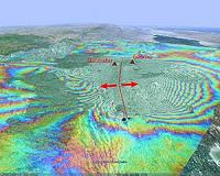
Bonn, Germany (SPX) Oct 21, 2010 The TanDEM-X and TerraSAR-X satellite pair have acquired their first image of Earth's surface, synchronised to the microsecond, while flying over Mount Etna in Italy. Scientists at the German Aerospace Center have used the data to create a three-dimensional digital elevation model with an unprecedented elevation accuracy down to two metres. The image, taken while the satellites were flying just 350 metres apart, is the first in the world to be made by satellites flying in such a close formation. The image shows Mount Etna on the east coast of Sicily. On the left of the image, in the foothills of the volcano, the city of Catania is visible as a collection of white points. This three-dimensional view of the volcano was generated from data recorded by TanDEM-X and TerraSAR-X. This was acquired using bistatic radar, where one of the satellites transmits a radar signal to Earth and the two satellites receive the reflection of this signal simultaneously. In this way, a highly accurate three-dimensional terrain model is created on a 12-metre grid. A similar recording technique was used in the Shuttle Radar Topography Mission (SRTM) in February 2000. However, in this case only 60 percent of Earth's surface was imaged, and at a coarser grid spacing of 30 to 90 metres.
Satellite pair captures detail from space In the area of the actual crater especially and along the flanks of the volcano there are differences of up to 30 metres. This is partly down to the greater accuracy of the elevations measured by TanDEM-X and TerraSAR-X; as they flew over at an altitude of over 500 kilometres, the two radar satellites were able to detect detail on Etna that SRTM could not resolve. The other reason is that the volcano and its environs have changed over the course of the years; for example, to the south (left in the image) a lava flow from 2001 can be seen. The modern images use a finer measurement grid and enable geodynamic processes to be monitored. To create the three-dimensional elevation model of the entire land surface of Earth, the two satellites will fly over and image every area multiple times.
New images of the Eyjafjallajokull volcano The colours indicate the height of the terrain; the peaks of the volcanoes are shown in white, while the lowlands where the melt water flows in spring are shown in green. The volcano's crater, which was exposed from beneath the ice by its activity, is easily recognisable. To the right, another volcano, Katla, is 'slumbering' beneath a massive ice cap. The indentations visible in the ice indicate that this volcano is also active and that its ice cap is melting and collapsing as a result. Areas such as Iceland are being mapped in elevation for the first time by the radar satellites flying in formation, as the elevation model created by SRTM only reached 60 degrees latitude.
Patented discoveries Until now, DLR researchers had been letting the two satellites look at the Earth asynchronously, while they were still flying 20 kilometres from each other. In this way they created around 2000 elevation models of different regions. The elevation models being produced now, however, have been processed using data captured synchronously by the satellites. To automatically calculate the 3D elevation models, DLR has developed algorithms specifically for the mission. "Processing the bistatic pairs of data is a big challenge. Everything must match up exactly in order to reach this level of precision. All sorts of data can affect the algorithms, from synchronisation signals to millimetre-accurate orbital calculations," says DLR processing engineer Thomas Fritz. "All the systems involved, from calculating and planning the imaging to processing the elevation data have worked perfectly," confirms Birgit Schattler, who is responsible for commissioning the ground segment.
Future applications In an initial successful test, DLR researchers observed the islands of Franz Josef Land in the Arctic Ocean. As if frozen in time, even the wave pattern of the sea can be recognised in the elevation model of the island group. Oceanography or climate researchers can also use such images to precisely analyse ocean currents, for example. In this image the highest areas are coloured white - the colour scheme thus roughly corresponds to the formation of ice on the islands.
Milestone on the way to a 3D elevation model of the Earth The data acquired can be used for mapping the landscape, city planning and navigation, as well as for mission planning in disaster areas. It can also be used for scientific research in glacial, earthquake or volcanic regions.
Public-private partnership The TanDEM-X mission is being operated by the German Aerospace centre (DLR) with funding from the German Federal Ministry for Economics and Technology (Bundesministerium fur Wirtschaft und Technologie; BMWi), in the form of a public-private partnership with Astrium GmbH.
Share This Article With Planet Earth
Related Links German Aerospace Center Earth Observation News - Suppiliers, Technology and Application
 Insight Into Volcanic Eruptions, Courtesy Of Space
Paris, France (ESA) Oct 19, 2010 Scientists are crediting satellite imagery with helping to predict where volcanic eruptions could strike. It is well known that earthquakes can stress Earth's crust and trigger subsequent quakes, but there has been no proof of this for volcanoes until now. In September 2005, a volcanic event in Ethiopia's Afar Desert forced magma up through rocks in a crack, known as a dyke, resulting in a ... read more |
|
| The content herein, unless otherwise known to be public domain, are Copyright 1995-2010 - SpaceDaily. AFP and UPI Wire Stories are copyright Agence France-Presse and United Press International. ESA Portal Reports are copyright European Space Agency. All NASA sourced material is public domain. Additional copyrights may apply in whole or part to other bona fide parties. Advertising does not imply endorsement,agreement or approval of any opinions, statements or information provided by SpaceDaily on any Web page published or hosted by SpaceDaily. Privacy Statement |


 del.icio.us
 Digg
Digg Reddit
 YahooMyWeb
 Google