|
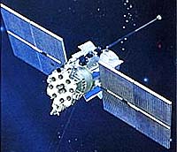
Moscow, November 20 (RIA Novosti) Russia will put into orbit three Glonass navigation satellites on December 25 from the Baikonur space center in Kazakhstan, Russia's space agency said on Thursday. "The first of three Glonass navigation satellites has been delivered to the space center by an Il-76 plane. The second and third satellites will arrive at Baikonur in 10 days," a Roscosmos spokesman told RIA Novosti. Glonass - the Global Navigation Satellite System - is the Russian equivalent of the U.S. Global Positioning System, or GPS, and is designed for both military and civilian use. Both systems allow users to determine their positions to within a few meters. According to the Central Research Institute for Machine Building, the Glonass system currently consists of 19 satellites, of which 16 are operational, two are undergoing maintenance, and one is one due to be withdrawn. The Glonass system requires 18 satellites for continuous navigation services covering the entire territory of the Russian Federation, and 24 satellites to provide services worldwide. A total of 9.9 billion rubles ($360 million at the current exchange rate) was allocated for Glonass from the federal budget in 2007, and 4.7 billion rubles ($170 million) in 2006. Russian Prime Minister Vladimir Putin signed a directive on September 12 allocating an additional $2.6 billion to develop the system. Roscosmos chief Anatoly Perminov said in September that the number of satellites in the Glonass network would be increased to 30 by 2011.
Source: RIA Novosti Related Links Glonass GPS Applications, Technology and Suppliers
 London, UK (SPX) Nov 24, 2008
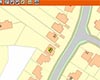
Infoterra has partnered with Stanfords Business Mapping, a leading retail supplier of paper mapping and map data for businesses, to develop a cost-effective new geographical asset management system - Stanfords GIS - for organisations managing property portfolios. This new system incorporates mapping and aerial photography in a secure, web-based management interface to provide an integrated geographical property database. |
|
| The content herein, unless otherwise known to be public domain, are Copyright Space.TV Corporation. AFP and UPI Wire Stories are copyright Agence France-Presse and United Press International. ESA Portal Reports are copyright European Space Agency. All NASA sourced material is public domain. Additional copyrights may apply in whole or part to other bona fide parties. Advertising does not imply endorsement, agreement or approval of any opinions, statements or information provided by Space.TV Corp on any Web page published or hosted by Space.TV Corp. Privacy Statement |