 |
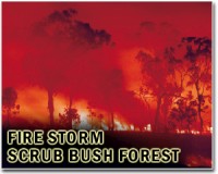
Munich, Germany (SPX) Jan 17, 2011 Forest fires usually spread out of control very quickly. Fires that produce a lot of smoke are particularly challenging for the emergency services, because the source of the fire is then especially hard to find. A new radiometric sensor can pinpoint the heart of the flames, even when visibility is limited. The number and scale of forest fires has increased dramatically in recent decades. Who can forget last summer's television images of blazing infernos devouring miles and miles of forest in Russia, Australia and California? In Germany, too, several regions are under threat precipitated by climate change - Brandenburg, for example, is one of the areas of Europe that are most at risk. Often, fires can only be contained from the air. In order to fight them in a targeted way, firefighting planes need to be given precise information on where the flames are at their worst. Infrared (IR) cameras have long been a trusted aid, since fire glows most intensely in the infrared range. IR cameras measure the intensity of the heat radiation emanating from a forest fire, and this leads them to its source. But despite the high-resolution images such cameras produce, they cannot be used to find the source of a fire in very smoky conditions because the dust and smoke severely dim the infrared rays. Researchers from the Fraunhofer Institute for High Frequency Physics and Radar Techniques FHR in Wachtberg have found a way around this problem by developing a radiometer that can scan fires even when visibility is limited. The radiometric sensor works in the microwave range between 8 and 40 GHz. At these low frequencies, radiation is scattered far less by dust particles than at the high IR frequencies. "Measurements we took during testing showed that the dimming effect was negligible at 22 GHz. Particles of dust and smoke are practically transparent in the microwave range, but the radiation is still strong enough for the source of a fire to be detected. From a height of 100 meters, we were able to locate fires measuring five meters by five meters in low visibility conditions," says Dipl.-Ing. Nora von Wahl of Fraunhofer FHR. For the test flights, the scientist and her team mounted the microwave sensors on the underside of an unmanned airship belonging to the FernUniversitat Hagen. "Along with the sensors themselves, the radiometer comprises a calibrating unit, a planar antenna array, and software for recording and visualizing the data," says von Wahl. The system's resolution is determined by the antenna's angular aperture, so it depends on the size of the antenna, the frequency and the distance from the ground. Using an antenna measuring 20 centimeters at its outer rim, operated at a frequency of 22 GHz and from a height of 30 meters, the radiometer can resolve details on the ground to a grid accuracy of 2.6 meters. "The radiometer doesn't give us as much detail as an infrared camera," says the scientist, "but if we increase the size of the antenna we can achieve higher resolution." The radiometric sensor allows the researchers to locate pockets of fire even behind a curtain of foliage. "After a forest fire, it is often the case that new fires start underground. To find them, firefighters have to go in and dig around by hand. Our radiometer can detect fires below the top layer of earth," says von Wahl. She goes on to explain that the system is principally suited to fire protection with firefighting planes, but could also be used to monitor industrial sites. This would, for instance, enable early detection of smoldering fires at waste incineration plants. The radiometer, which measures 105 by 150 by 73 millimeters, is currently a prototype. The scientists' aim is to make the device even smaller, and they also want to optimize the antenna. Future designs will be based on microchips.
Share This Article With Planet Earth
Related Links Fraunhofer Institute Forest and Wild Fires - News, Science and Technology
 China tightens building rules after deadly fire
Shanghai (AFP) Jan 12, 2011 Authorities in Shanghai have pledged to step up supervision of construction projects, nearly two months after a fire engulfed a high-rise apartment building in the Chinese city and left 58 dead. A preliminary investigation blamed the inferno in the 28-storey block on careless work by unlicensed welders who ignited nylon netting swathing the building, which was being renovated to improve ener ... read more |
|
| The content herein, unless otherwise known to be public domain, are Copyright 1995-2010 - SpaceDaily. AFP and UPI Wire Stories are copyright Agence France-Presse and United Press International. ESA Portal Reports are copyright European Space Agency. All NASA sourced material is public domain. Additional copyrights may apply in whole or part to other bona fide parties. Advertising does not imply endorsement,agreement or approval of any opinions, statements or information provided by SpaceDaily on any Web page published or hosted by SpaceDaily. Privacy Statement |


 del.icio.us
 Digg
Digg Reddit
 YahooMyWeb
 Google