|
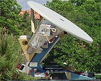
Las Cruces NM (SPX) Jun 12, 2008 Farmers looking for the best time to irrigate can get help from weather satellites orbiting the earth on a regular basis. Those same satellites can also help fire fighters battling forest fires and emergency workers trying to understand the scope of a major snow storm. The only problem - no one in the Southwest was able to collect that data. That was until New Mexico State University's CARSAME program got off the ground. The Center for Applied Remote Sensing in Agriculture, Meteorology, and Environment (CARSAME) began as a cooperative effort between the U.S. Army Research Laboratory and NMSU's College of Agriculture and Home Economics, Physical Science Laboratory and N.M. Space Grant Consortium. "We feel we can provide a service, collecting data for other research projects," said Max Bleiweiss, an adjunct professor at NMSU. "Using hydrology modeling, we can account for the water in the Rio Grande Basin. With this satellite data, we can also observe land surface temperatures, monitor dust storms and the growth of vegetation." The project uses remote sensing stations to collect information from the National Oceanic and Atmospheric Administration's polar orbiting satellites. The satellites scan the earth and send back visible wavebands, middle infrared bands and thermal images. The data is used primarily for meteorological purposes, monitoring the atmosphere and the earth's surface. The satellites are constantly orbiting the earth, but without a regional station to collect their data, the information they beam back to earth is lost. Other than CARSAME, there are no other collection stations in New Mexico, West Texas, Colorado or Arizona. Bleiweiss worked with the remote sensing project beginning more than a decade ago at White Sands Missile Range. After a few years, the U.S. Army Research Laboratory decided to move away from the project, and donated all of the equipment to NMSU. Bleiweiss credits a Ph.D. student in his group, Scott Williams, for putting together the technical aspect of the project. Before Williams, the antennas were simply sitting as boxes of parts in storage. Williams has two stations, Cumulus and Humilis, up and running. He hopes to have up to three additional antennas online in the future. Williams is currently studying computational agriculture at NMSU. "What we are seeing is agriculture, along with everything else, going to more computational areas," said Williams. "What I'm trying to do is put a stake in the ground and hopefully attract more researchers and students to this area." "It's not just agriculture that we are working with at CARSAME," Bleiweiss said. "It's also environmental sciences. With this information, we can study the effects of climate change and see how earlier snowmelt and earlier water runoff affect stream flows." The group is also working with the National Geospatial-Intelligence Agency and PSL on flashflood modeling and working with UTEP on dust storm modeling and detection. "We are studying how and why these dust storms form so, for example, we can give the Department of Transportation more advanced and accurate information," Bleiweiss said. CARSAME participates in the Rio Grande Basin Initiative, a partnership between NMSU and Texas A and M University for water conservation along the Rio Grande. Related Links CARSAME Earth Observation News - Suppiliers, Technology and Application
 Greenbelt MD (SPX) Jun 10, 2008
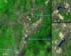
The Sichuan earthquake in China occurred on May 12, 2008, along faults within the mountains, but near and almost parallel the mountain front, northwest of the city of Chengdu. This major quake caused immediate and severe damage to many villages and cities in the area. |
|
| The content herein, unless otherwise known to be public domain, are Copyright Space.TV Corporation. AFP and UPI Wire Stories are copyright Agence France-Presse and United Press International. ESA Portal Reports are copyright European Space Agency. All NASA sourced material is public domain. Additional copyrights may apply in whole or part to other bona fide parties. Advertising does not imply endorsement, agreement or approval of any opinions, statements or information provided by Space.TV Corp on any Web page published or hosted by Space.TV Corp. Privacy Statement |