 |
Greenbelt MD (SPX) Sep 21, 2010 The Moderate Resolution Imaging Spectroradiometer or MODIS, is an instrument that flies on NASA's Aqua and Terra satellites and provides incredible views of tropical cyclones like Hurricane Igor, from its vantage point in space. Imagery from the MODIS instruments on these two satellites captured from Sept. 18 to 20 showed that powerful Hurricane Igor in the Atlantic Ocean is morphing from a rounded storm to more of a comma-shaped storm. The MODIS instrument on NASA's Terra satellite captured a visible image of Igor at 11:30 am on Sept. 18, while MODIS in the Aqua satellite captured Igor's center just southwest of Bermuda on Sept. 19 at 1:30 p.m. EDT. In imagery on both days, Hurricane Igor maintained a rounded shape and its eye was cloud-filled. When the MODIS instrument that flies aboard NASA's Terra satellite captured Igor after it passed Bermuda on Sept. 20 at 11:15 a.m. EDT, the imagery showed the Igor appeared elongated from south to north, and more resembled a comma-shape. There was even an eye visible in the latest image. The Atmospheric Infrared Sounder Instrument (AIRS) that flies on NASA's Aqua satellite captured infrared images of Hurricane Igor's cold cloud temperatures and cloud cover on Sept. 18, Sept. 19, and Sept. 20. Igor lost its circular shape by Sept. 20, and there were very few high, strong thunderstorms where the cloud tops were colder than -63F. Infrared data from AIRS on Sept. 20 indicated that Igor was losing its strength as the cloud tops in the thunderstorms within were warming (less high in the atmosphere) and waning. NASA and JAXA's Tropical Rainfall Measuring Mission (TRMM) satellite also continues to fly over Igor as he makes his track northward in the Atlantic Ocean. Hurrricane Igor continued to weaken as the Tropical Rainfall Measuring Mission (TRMM) satellite passed over on September 19, 2010 at 0144 UTC showing that the hurricane no longer had an eye. Igor's wind speeds had decreased to about 75 knots (~86 mph) when TRMM collected the TRMM Microwave Imager (TMI) data used in the precipitation analysis. TRMM is managed by both NASA and the Japanese Space Agency. By 2p.m. EDT on Sept. 20, all warnings and watches for Bermuda had been discontinued. Igor had moved about 350 miles north-northeast of Bermuda and was headed into the North Atlantic. It was located near 37.1 North and 62.5 West. Now, a tropical storm watch is in effect for the coast of Newfoundland from Stones Cove northward and Westward to Jones Harbour, Canada.
Share This Article With Planet Earth
Related Links NASA/Goddard Space Flight Center Earth Observation News - Suppiliers, Technology and Application
 A Growing La Nina Chills Out The Pacific
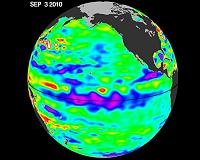
Pasadena CA (JPL) Sep 17, 2010 The tropical Pacific Ocean has transitioned from last winter's El Nino conditions to a cool La Nina, as shown by new data about sea surface heights, collected by the U.S-French Ocean Surface Topography Mission (OSTM)/Jason-2 oceanography satellite. This OSTM/Jason-2 image of the Pacific Ocean is based on the average of 10 days of data centered on Sept. 3, 2010. A new image depicts places w ... read more |
|
| The content herein, unless otherwise known to be public domain, are Copyright 1995-2010 - SpaceDaily. AFP and UPI Wire Stories are copyright Agence France-Presse and United Press International. ESA Portal Reports are copyright European Space Agency. All NASA sourced material is public domain. Additional copyrights may apply in whole or part to other bona fide parties. Advertising does not imply endorsement,agreement or approval of any opinions, statements or information provided by SpaceDaily on any Web page published or hosted by SpaceDaily. Privacy Statement |


 del.icio.us
 Digg
Digg Reddit
 YahooMyWeb
 Google