|
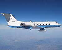
Edwards CA (SPX) Nov 28, 2007 NASA is evaluating a compact L-Band synthetic aperture radar for potential use on unmanned aircraft. The sensor detects and measures small changes in Earth"s surface of geophysical interest, such as volcanoes, earthquake faults, landslides and glaciers. NASA's Jet Propulsion Laboratory, Pasadena, Calif., and Dryden Flight Research Center, Edwards, Calif., are partnering in development of the Unmanned Aerial Vehicle Synthetic Aperture Radar (UAVSAR). A modified NASA Gulfstream III aircraft carries the JPL-developed radar in a custom-built pod under the aircraft's fuselage during its development phase. "The system is an imaging radar. It is like a camera that uses microwaves to make an image," said Scott Hensley, chief scientist for the project at JPL. "It collects data to measure the deformation of Earth's surface, for example from an earthquake or volcano. This will help us better understand how earthquakes and volcanoes work. The way we do that is through the signatures of how they deform Earth's surface." "The UAVSAR is a flying test bed for developing the tools and technologies for future space-based radars," said Robert Smith, UAVSAR program manager for NASA"s Earth Science Technology Office. "Once operational, it will also be a powerful airborne instrument providing calibration data and rapidly repeated images scientists need to augment data obtained from satellites." During these validation flights, the aircraft is using a technique known as repeat pass interferometry that requires the aircraft to fly each pass as close to the original flight line as possible. For the experiment, two data passes, flown from minutes to months apart, are compared to examine changes in Earth's surface. To ensure the accuracy of the flight paths, a precision autopilot designed by engineers at Dryden has been installed on the test aircraft. The autopilot guides the aircraft using the differential Global Positioning System and the aircraft's inertial navigation system to repeat the flight path to an accuracy of within 4.6 meters (15 feet). With the precision autopilot engaged, the synthetic aperture radar will be able to acquire repeat pass data that can measure changes with a resolution measured in millimeters. "We're very pleased with the performance of the Platform Precision Autopilot, and feel confident that this new system, along with the structurally modified G-III aircraft, is ready to fully support UAVSAR interferometry studies," said Frank Cutler, project manager for the Gulfstream III UAVSAR flight testing at NASA Dryden. During the 1990s, scientists used NASA"s DC-8 airborne science laboratory to collect data with the airborne synthetic aperture radar (AIRSAR) system, also developed at JPL. The UAVSAR instrument currently under development has benefited from technology advancements in the 20 years since AIRSAR was built. The prototype UAVSAR is smaller, fitting into a pod about three meters (10 feet) in length. The radar pod is a self-contained instrument package that requires only electrical power from the aircraft. The instrument has its own navigation system consisting of a high-accuracy inertial navigation unit and a differential GPS developed at JPL that provides the aircraft's location to an accuracy of less than one meter (three feet). The radar's electronically steered antenna compensates for aircraft attitude changes as the radar makes repeated passes over areas of interest. The pod also contains a two-terabyte recorder to store the large amounts of data generated by the radar. The pod is designed to operate autonomously by loading commands to the system's computer prior to flight. Along with the autopilot, the design of the pod allows it to be flown on a variety of aircraft, including unmanned aircraft. The sensor is currently undergoing a one-year development and test period to improve robustness and validate its ability to meet the science objectives. The UAVSAR will be extensively tested through 2008, after which it will become a community science tool for NASA. Related Links G-III UAV News - Suppliers and Technology
 Arlington, Va. (UPI) Nov 27, 2007
 Seven years into the new millennium, military planners have figured out that the biggest challenge they face is finding the enemy. |
|
| The content herein, unless otherwise known to be public domain, are Copyright Space.TV Corporation. AFP and UPI Wire Stories are copyright Agence France-Presse and United Press International. ESA Portal Reports are copyright European Space Agency. All NASA sourced material is public domain. Additional copyrights may apply in whole or part to other bona fide parties. Advertising does not imply endorsement, agreement or approval of any opinions, statements or information provided by Space.TV Corp on any Web page published or hosted by Space.TV Corp. Privacy Statement |