|
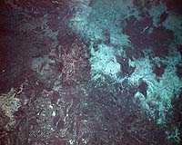
Columbia MO (SPX) Feb 06, 2007 Earthquakes and volcanic activity occur when the tectonic plates that make up Earth's surface move apart or converge. While this activity is relatively easy to observe on land, it's more difficult to observe under the ocean, where most of it occurs. A University of Missouri-Columbia researcher will soon undertake a study to learn more about this process by placing sensors on a mid-ocean ridge called the East Pacific Rise. "Right now, we can only listen from land using seismometers, or in the oceans using hydrophones, and try to find out when there is activity in a mid-ocean ridge," said Marie-Helene Cormier, assistant professor of geological sciences in MU�s College of Arts and Science. "We might not know for a few days, and then it might take at least a week to get a ship to the site. If we want to study what's happening, it's very difficult to get accurate and timely information. Our goal is to put sensors in place so that we can record activity as it is happening. When we recover our sensors, we'll be able to study what was happening during those moments." In mid February, Cormier and her colleagues, Spahr Webb and Roger Buck of Columbia University, will place sensors on the seafloor in multiple positions along the East Pacific Rise southwest of Mexico. The sensors will measure and record changes in the pressure of the water column above them. Cormier said the pressure of the water is expected to decrease during ridge activity because magma flows up between the two plates, creating new seafloor and raising the height of the sensors by a few inches. She and her team will collect data from the sensors while they are in place until they are removed from the ocean floor in 2009 or 2010. MU undergraduate students are expected to accompany Cormier on the research mission to learn more about geology and marine research. "We expect there will be activity in this area while the sensors are there," Cormier said. "We'll measure, use computer models and compare data of the seascape from previous missions to this area to learn more about what's happening." The data from this study could help scientists better understand what happens when tectonic plates move apart. This activity can cause underwater volcanic eruptions and earthquakes that result in the cycling of large quantities of seawater through the ocean floor, creating a nutrient-rich environment for bacteria and microorganisms. Cormier said the new magma and heat that come from below the earth's surface attract organisms to the new nutrient-rich, warm waters that are expelled from the seafloor. "We want to understand more about what's happening under the oceans," Cormier said. "We can look at maps of Earth and see many details about the landforms above sea level, but we don't know nearly as much about what's under the ocean. Seventy percent of our land is under the ocean, so it's important to map out what landforms there are and understand what's happening there." This research is supported by a National Science Foundation (NSF) grant. Through its "Research Experience for Undergraduates" initiative, the NSF also has approved some funds to assist the undergraduate students in their participation in the expedition. Related Links NOAA Ocean Explorer Coordination of various experiments RIDGE 2000 Initiative National Science Foundation Research vessel ATLANTIS University of Missouri When the Earth Quakes Tectonic Science and News
Researchers report that an approach used for years to understand the structure of Earth's oceanic crust is flawed and geoscientists will have reconsider the correspondence between seismic data and rock units when mapping formations of young oceanic crust. |
|
| The content herein, unless otherwise known to be public domain, are Copyright Space.TV Corporation. AFP and UPI Wire Stories are copyright Agence France-Presse and United Press International. ESA Portal Reports are copyright European Space Agency. All NASA sourced material is public domain. Additional copyrights may apply in whole or part to other bona fide parties. Advertising does not imply endorsement, agreement or approval of any opinions, statements or information provided by Space.TV Corp on any Web page published or hosted by Space.TV Corp. Privacy Statement |