|
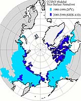
Ottawa (AFP) Jan 31, 2007 Canada and the United States have launched a satellite mapping project of North America to better monitor biodiversity and climate change in the region, Natural Resources Canada said Wednesday. "Using infrared, radar relief and other remote-sensing techniques, the partnership will produce integrated information that will help natural resources managers better assess the health of landscapes, cross-border wildland fire risks, changes in biodiversity and the effects of climate change on permafrost," the ministry said in a statement. Permafrost is ground that stays at or below the freezing point of water for two or more years, and is a key indicator of global warming. "Working together, this partnership will allow us to share information and maximize our scientific knowledge so that we can better monitor the changes of our land, including the permafrost areas in the North," said Natural Resources Minister Gary Lunn. Joint efforts in the development of permafrost applications will focus first on mapping the Yukon River basin, the ministry said. "A key application in joint permafrost mapping will be assessing the impacts of climate change on human settlements, physical infrastructure and ecosystems in both countries," the statement added.
Source: Agence France-Presse Related Links Making money out of watching earth from space today Earth Observation News - Suppiliers, Technology and Application
 Rio De Janeiro, Brazil (XNA) Feb 02, 2007
Brazil's National Institute of Space Research (INPE) said on Wednesday that CBERS-2B, the third satellite to be launched in cooperation with China, is being assembled, integrated and tested. From Monday on, the satellite will undergo electromagnetic interference tests, as well as tests to detect leaks in the propelling system, and to measure mass, vibration and acoustics, the INPE said. |
|
| The content herein, unless otherwise known to be public domain, are Copyright Space.TV Corporation. AFP and UPI Wire Stories are copyright Agence France-Presse and United Press International. ESA Portal Reports are copyright European Space Agency. All NASA sourced material is public domain. Additional copyrights may apply in whole or part to other bona fide parties. Advertising does not imply endorsement, agreement or approval of any opinions, statements or information provided by Space.TV Corp on any Web page published or hosted by Space.TV Corp. Privacy Statement |