 |
White Plains NY (SPX) Jan 03, 2007 ITT has announced that as part of an Air Force-sponsored program, ITT has developed and delivered an advanced imagery management and dissemination solution for the Air Force that provides high-resolution, large-file imagery at high speed over low bandwidth to combat forces. The new system incorporates the Advanced Geospatial Imagery Library Enterprise (AGILE) technology developed by ITT. Adhering to National Geospatial-Intelligence Agency (NGA) NITF/JPEG2000 imagery standards, the system receives processed and unexploited imagery from various Intelligence, Surveillance, and Reconnaissance (ISR) sources, while providing the framework necessary for managing hundreds of images collected daily . This allows combat forces to quickly locate and access current imagery. Based on original image sensor metadata, the solution incorporates a Web-based Search and Discovery feature to facilitate a user's ability to rapidly find and retrieve desired images. A key feature of the system is its ability to disseminate imagery in near real time to users in the field at low bandwidths - even below 10Kbps. This is accomplished through dynamic access of the full frame image, This dynamic access makes the imagery readily available to tactical users where limited communications inhibits access to imagery and reduces the time for tactical decision making from days/hours to minutes/seconds. "Our challenge is to significantly shorten the time it takes for critical users to obtain this high-resolution imagery," said Bruce Wald, Vice President and Director, Image Information Solutions, ITT Space Systems Division. "Prior systems were slow because of difficulty sending large volumes over a small bandwidth. Our solution, which uses a non-proprietary architecture based on open standards for advanced compression and wavelet dissemination, allows the Air Force to deliver imagery far more rapidly." The core component of the system is the Image Access Solutions (IAS) commercial software product from ITT. It is the engine that provides data conversion, compression and dynamic image access. IAS software allows you to deliver, visualize, and integrate imagery with geospatial data for time-sensitive surveillance and reconnaissance missions. Follow-on efforts with the Air Force will integrate ITT technology into the Distributed Common Ground Station Integrated Backbone (DIB) and Global Command and Control System architectures. This will dramatically extend the numbers of users who will be able to benefit from the technology. Related Links ITT Corporation Making money out of watching earth from space today Earth Observation News - Suppiliers, Technology and Application
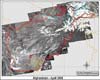 Guildford, UK (SPX) Jan 03, 2007
After extensive trials in 2005, DMC International Imaging (DMCii) won a contract from the UK Government to supply high-resolution satellite coverage of the whole of Afghanistan to support the surveying of opium crops. The Disaster Monitoring Constellation (DMC) coordinated by DMCii includes the UK's own satellite, as well as four satellites built at the Surrey Space Centre for other DMC member nations; Algeria, China, Nigeria and Turkey. |
|
| The content herein, unless otherwise known to be public domain, are Copyright Space.TV Corporation. AFP and UPI Wire Stories are copyright Agence France-Presse and United Press International. ESA Portal Reports are copyright European Space Agency. All NASA sourced material is public domain. Additional copyrights may apply in whole or part to other bona fide parties. Advertising does not imply endorsement, agreement or approval of any opinions, statements or information provided by Space.TV Corp on any Web page published or hosted by Space.TV Corp. Privacy Statement |
