|
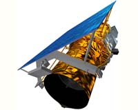
Gilbert AZ (SPX) Apr 10, 2008 General Dynamics Advanced Information Systems has announced the completion of satellite integration and environmental testing for GeoEye's next-generation earth imaging satellite, GeoEye-1. General Dynamics is the prime contractor and integrator of the spacecraft and telescope for GeoEye. GeoEye-1 will remain at the General Dynamics space systems facility until it is shipped to Vandenberg Air Force Base, Calif. for launch this summer. "GeoEye-1 has now completed testing based on our proven processes that resulted in the successful in-orbit performance of all 10 satellites previously built by General Dynamics," said David Shingledecker, vice president and general manager of integrated space systems, General Dynamics Advanced Information Systems. "We look forward to the launch of GeoEye-1 and its world-class earth imaging capabilities." "The completion of environmental testing is a major milestone on the road to launch," said Bill Schuster, GeoEye's chief operating officer. "The satellite was delivered on budget without any change orders which often increase costs. GeoEye-1 and this class of satellites are an ideal system for broad-area imagery collection and mapping for our government and commercial customers." GeoEye-1 is part of the National Geospatial-Intelligence Agency (NGA) NextView program. The NextView program is designed to ensure that the NGA has access to commercial imagery in support of its mission to provide timely, relevant and accurate geospatial intelligence in support of national security. When operational, GeoEye-1 will be the world's highest resolution commercial imaging satellite, designed to take highly precise images of the Earth from 425 miles (684 kilometers) in space. The 4,310 pound satellite will collect imagery that can distinguish objects on the Earth's surface as small as 0.41 meters or about 16 inches in size. Related LinksGeneral Dynamics Advanced Information Systems Earth Observation News - Suppiliers, Technology and Application
 Columbus OH (SPX) Apr 10, 2008
NASA and Battelle plan to save consumers money on their electric and gas bills. Using high-tech data made available from Americas space agency, Battelle will help utility companies better predict when energy supplies will be needed. Battelle recently won a three-year, $640,000 contract from NASA that focuses on applying high-resolution, weather-related Earth science data to key systems used by energy utilities for short-term load forecasting. |
|
| The content herein, unless otherwise known to be public domain, are Copyright Space.TV Corporation. AFP and UPI Wire Stories are copyright Agence France-Presse and United Press International. ESA Portal Reports are copyright European Space Agency. All NASA sourced material is public domain. Additional copyrights may apply in whole or part to other bona fide parties. Advertising does not imply endorsement, agreement or approval of any opinions, statements or information provided by Space.TV Corp on any Web page published or hosted by Space.TV Corp. Privacy Statement |