|
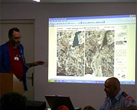
Bonn, Germany (SPX) Jun 17, 2008 In Cyprus, disaster management experts of the European Union tested a satellite based system for monitoring disaster areas. On behalf of the European Commission, the German Aerospace Center (DLR) has developed a system that enables disaster relief workers to access up to date satellite images while being in the field and exchange data among themselves. The exercise took place in the framework of the EU-project LIMES (Land and Sea Integrated Monitoring for European Security), which develops and applies satellite-based technologies in the field of security for Europe. With the disaster training, the German Agency for Technical Relief (THW) and the medical help organisation "Johanniter Unfallhilfe" trained for emergencies under realistic conditions on the basis of a simulated earthquake, including a tsunami near the southern coast of Cyprus. The involved LIMES partners brought together their expertise to jointly support the disaster relief workers with up to date satellite images and satellite maps as well as communication and on-site navigation technologies. Finally, the satellite-based monitoring system has been demonstrated to the Cypriot Minister of the Interior, Neoklis Silikiotis, and the German ambassador, Rolf Kaiser, on June 11th, 2008. Further, the United Nations is working to provide a web-based knowledge portal for disaster management and emergency measures for the disaster relief workers. Coordinated by the UN-SPIDER programme (United Nations Platform for Space-based Information for Disaster Management and Emergency Response), this platform will soon offer the opportunity to supplement satellite scenes and maps following a disaster with information gained on the ground. "With this freely available service, we can fulfil an important aspect of the UN-SPIDER mandate and ensure that all states and relief organisations receive quicker access to space-based information", said Joirg Szarzynski from the UN-SPIDER Office in Bonn. The rapid access to such information is necessary because, after disasters like the earthquake in China or the cyclone in Myanmar, rescue teams need to find out as soon as possible what type of aid is needed where. Support is given by the new system from space: with the help of satellite images, the relief workers receive an overview on blocked roads or destroyed buildings. By means of computer software, they then synchronise their observations on the ground with the satellite images and feed the data to a specialised network via satellite. The system is still in the prototype stage, but soon all involved organisations will be able to access the data directly over the network and supplement them with their own information. The aim is to speed up the investigation of disaster areas so that the exact support that is needed arrives as soon as possible. "We want powerful satellite technology to be used quickly and effectively in case of emergency", said Michael Angermann from DLR. The prototype will be enhanced for civil protection in the coming months. "At the end it shall be as easy to use as a laptop or a phone without costing more", the developers said. "The more field teams are able to connect with each other, share their results and transfer them, the quicker and more effectively the international community will be able to help", said Claus Hoillein from the German Agency for Technical Relief (THW). Together with the medical help organisation "Johanniter Unfallhilfe" and the Cypriot Civil Protection, the THW regularly trains European investigation experts on behalf of the European Union. In the context of advanced training, eleven investigators from various countries will be testing the new system under realistic operational conditions during the training exercise. The one-week "Assessment Mission Course" (AMC) is part of an EU mechanism that has been supporting international cooperation in civil protection since 2002. An important part of the mechanism consists of common trainings and seminars for relief units from all over Europe. The civil protection organisations are connected by a headquarter in Brussels and a communication network to provide assistance. Recently, EU experts have been active after the earthquake in China and the cyclone in Myanmar. Related Links German Aerospace Center (DLR) Bringing Order To A World Of Disasters A world of storm and tempest When the Earth Quakes
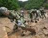 Kurihara, Japan (AFP) June 16, 2008
Rescue workers hampered by giant mounds of mud pulled a man's body out of the remains of a devastated hot spring resort on Monday, bringing the death toll from Japan's earthquake to 10. |
|
| The content herein, unless otherwise known to be public domain, are Copyright Space.TV Corporation. AFP and UPI Wire Stories are copyright Agence France-Presse and United Press International. ESA Portal Reports are copyright European Space Agency. All NASA sourced material is public domain. Additional copyrights may apply in whole or part to other bona fide parties. Advertising does not imply endorsement, agreement or approval of any opinions, statements or information provided by Space.TV Corp on any Web page published or hosted by Space.TV Corp. Privacy Statement |