|
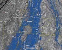
Bonn, Germany (SPX) Sep 05, 2008 After an embankment on the Koshi river in eastern Nepal was breached on 18 August 2008, there was extensive flooding. This affected more than three million people, destroying 250 000 homes in 1600 villages. The flooding was particularly severe in the Sunsari district as well as further south in the Supaul district of Bihar which is situated downstream in India. It also inundated the districts of Madhepura, Araria, Purnea and Saharsa. Damaged roads and flooded railway tracks have hampered relief efforts. To allow speedy help on the ground, relief efforts need current information not only about the affected areas but which parts of the infrastructure were still intact. The German Aerospace Center (DLR) with the help of radar images from space mapped the flood areas in detail. The Center for Satellite-Based Crisis Information (ZKI) of DLR in Oberpfaffenhofen near Munich used data from the German radar satellite TerraSAR-X, which launched last year. The maps illustrate the flooded area south of the breached embankment with many flooded settlements, roads and agricultural land. The analysis is based on TerraSAR-X StripMap and ScanSAR data acquired on 30 August and 1 September 2008. The repetition rate of data acquisition could be accelerated significantly by using the unique left-looking recording ability of TerraSAR-X for the 1 September data acquisition. In "normal" mode, the satellite looks to the right of the flight direction. To look left, it must be specially programmed. The Center for Satellite Based Crisis Information (ZKI) is a service of the German Remote Sensing Data Centre of DLR. Its task is the rapid acquisition, processing and analysis of satellite data in the event of natural and environmental disasters, in humanitarian relief activities and for civil security. The evaluations are tailored to the specific needs of national and international policy-makers and relief organisations. Related Links Center for Satellite Based Crisis Information German Aerospace Center Earth Observation News - Suppiliers, Technology and Application
 Boulder Co (SPX) Sep 04, 2008
Ball Aerospace and Technologies and DigitalGlobe have announced that Ball has begun the integration of the completed imaging instrument for the next-generation WorldView-2 commercial imaging satellite being built for DigitalGlobe. |
|
| The content herein, unless otherwise known to be public domain, are Copyright Space.TV Corporation. AFP and UPI Wire Stories are copyright Agence France-Presse and United Press International. ESA Portal Reports are copyright European Space Agency. All NASA sourced material is public domain. Additional copyrights may apply in whole or part to other bona fide parties. Advertising does not imply endorsement, agreement or approval of any opinions, statements or information provided by Space.TV Corp on any Web page published or hosted by Space.TV Corp. Privacy Statement |