|
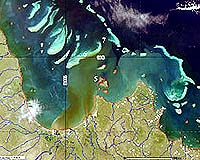
Canberra, Australia (SPX) Feb 28, 2007 A stunning series of satellite imagery of Australia's Great Barrier Reef released by the CSIRO shows for the first time visual confirmation of the theory that sediment plumes travel to the outer reef, and beyond. The remotely sensed images, taken from February 9 to 13 this year, challenge conventional thought that sediment travelling from our river systems into the GBR is captured by the longshore current and travels no more than 10 to 15km offshore, affecting only the inner Great Barrier Reef Lagoon and the inner reef corals. Images captured by CSIRO show large plumes of terrestrial material following unconventional patterns and travelling quite fast as far as 65 to 130km, to the outer reef and, in some instances, travelling along the outer reef and re-entering the reef. The plumes are the result of heavy rainfalls in northern QLD around late January to early February 2007, with the resulting flood waters carrying a larger sediment load than during regular rainfall and river flow. As such floods have not occurred for a while the accumulated material in the creeks ands rivers coupled with increased sediment runoff from the land is causing a significant transport of terrestrial material to all areas of the affected reefs and reef waters. Managers of the GBR have long been examining the effects of run-off of sediments, including pesticides, herbicides and fertilizers, on the reef corals. The images challenge the traditional school of hydrological modelling, which says sediment plume movement in the mid to northern GBR usually go north and never directly flow to the outer reef is spared the direct effects of such river floods. "A re-think is needed now that we know where flood plumes go," says CSIRO scientist Arnold Dekker, "and what this means as organic micropollutants may be travelling to parts of the reef scientists hadn't thought to look before." The images were taken from NASA's MODIS satellite by GeoScience Australia's Alice Springs site for a new product being developed by the Wealth from Oceans Flagship to track coastal and ocean events in real-time, building on the technology behind the successful SENTINEL [external link] bushfire tracking system. While extreme coastal events have been captured by remote sensing before, this is the first time they can be seen and analysed straight after the event as there are now more satellites imaging the Earth and CSIRO has invested in fast information delivery systems. Related Links CSIRO Making money out of watching earth from space today Earth Observation News - Suppiliers, Technology and Application
 Paris, France (ESA) Feb 23, 2007
More than 800 scientists from around the world will gather in Montreux, Switzerland, to attend the 2007 Envisat Symposium from 23 to 27 April to present and review results from ESA Earth observation satellites. The objectives of the largest ESA Earth observation (EO) symposium ever held are to provide a forum for investigators to present results of ongoing research project activities using data from Envisat, ERS and Third Party Missions and to review and assess the development of applications and services. |
|
| The content herein, unless otherwise known to be public domain, are Copyright Space.TV Corporation. AFP and UPI Wire Stories are copyright Agence France-Presse and United Press International. ESA Portal Reports are copyright European Space Agency. All NASA sourced material is public domain. Additional copyrights may apply in whole or part to other bona fide parties. Advertising does not imply endorsement, agreement or approval of any opinions, statements or information provided by Space.TV Corp on any Web page published or hosted by Space.TV Corp. Privacy Statement |