|
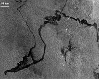
Paris, France (ESA) Mar 05, 2007 Mr Willem de Ruiter, Executive Director of the European Maritime Safety Agency (EMSA) and Mr Volker Liebig, ESA's Director of Earth Observation Programmes, signed an agreement between the two agencies, strengthening the framework for cooperation in the field of maritime monitoring and surveillance. The signature took place at the final preparatory stage of EMSA's new satellite-based oil spill monitoring service covering all European waters and adjacent high seas. Under this service, potential oil slicks are detected using satellite radar images and an alert is provided to EU coastal States and EMSA within 30 minutes of the satellite acquiring the image. This information is used in support of the aerial and vessel surveillance capabilities of coastal Member States to ensure that they detect and communicate all significant discharges. Under this arrangement, EMSA will be supported by ESA on issues relating to the development of space technologies for maritime monitoring and surveillance. In the light of its role as a long term operational European user of satellite technology, EMSA will advise ESA on user requirements for new space systems and infrastructure. According to Mr de Ruiter, "The agreement with ESA is very valuable for the new European oil spill monitoring service of the Agency. ESA's Earth observation satellite Envisat is an extremely powerful tool that will enable us to provide valuable additional services to EU Member States in the fight to control ship-sourced pollution." ESA has, for the last 30 years, been developing new space technologies, systems and associated applications, and transferring these for user activities. It recognises EMSA as a key European operational user of space technologies and satellite-derived information. Mr Liebig stated that, "we see this agreement with EMSA as a major milestone in the operational use of data from Earth observation satellites in Europe." The EC and ESA are developing the GMES (Global Monitoring for Environment and Security) initiative. The objective of GMES is to provide Europe with reliable, timely information on environmental and security issues on a sustainable basis, in support of public policy-makers' needs. The development of the GMES Space Component, coordinated by ESA, will ensure that organisations such as EMSA have guaranteed long term access to appropriate satellite observations in support of their environment- and security-related monitoring requirements. In particular, the Sentinel 1 satellite will ensure the continuity of the Envisat radar observations on which the new EMSA surveillance service is based. The availability of Earth observation products, particularly near-real-time radar covering wide areas, is essential for the long-term sustainability of EMSA's operational maritime monitoring and surveillance services. With this agreement, ESA affirms its strong commitment to taking into account EMSA's needs, both as regards the currently operational Envisat ASAR and also with respect to the preparation of future SAR missions. Launched in 2002, Envisat is the largest Earth observation spacecraft ever built. It carries ten sophisticated optical and radar instruments to provide continuous observation and monitoring of the Earth's land, atmosphere, oceans and ice caps. The data returned by its suite of instruments have facilitated and continue to facilitate the development of a number of operational and commercial applications. Related Links Observing the Earth Envisat overview GMES EMSA Bring Order To A World Of Disasters A world of storm and tempest Bringing Order To A World Of Disasters A world of storm and tempest When the Earth Quakes
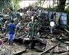 Kupang, Indonesia (AFP) March 04, 2007
Rescue teams have been sent by air to help find dozens of people still missing after deadly landslides buried villages in eastern Indonesia, officials said on Sunday. The landslides and flash floods on Flores island on Saturday killed at least 32 people, and distraught families reported another 38 were missing, said disaster relief coordinator Lazarus. |
|
| The content herein, unless otherwise known to be public domain, are Copyright Space.TV Corporation. AFP and UPI Wire Stories are copyright Agence France-Presse and United Press International. ESA Portal Reports are copyright European Space Agency. All NASA sourced material is public domain. Additional copyrights may apply in whole or part to other bona fide parties. Advertising does not imply endorsement, agreement or approval of any opinions, statements or information provided by Space.TV Corp on any Web page published or hosted by Space.TV Corp. Privacy Statement |