|
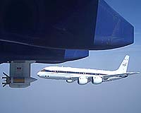
Greenbelt MD (SPX) Mar 07, 2007 Determined to understand why some storms grow into hurricanes while others fizzle, NASA scientists recently looked deep into thunderstorms off the African coast using satellites and airplanes. During July and August 2006, a team of international scientists, including NASA researchers, journeyed to the west coast of Africa. Their mission was to better understand why some clusters of thunderstorms that drift off the African coast, known as easterly waves, develop into furious hurricanes, while others simply fade away within hours. A major component of the campaign, called the NASA African Monsoon Multidisciplinary Analyses (NAMMA), was to study the Saharan Air Layer. The layer is a mass of very dry, dusty air that forms over the Sahara Desert and influences the development of tropical cyclones, the general name given to tropical depressions, storms and hurricanes. Budding hurricanes in the tropical Atlantic off the African coast often rapidly deteriorate when they interact with this stable air mass and its strong winds. This mission was unique because it incorporated NASA's state-of-the-art technology in space and in the air. With sophisticated satellite data and aircraft, scientists are better able to examine the "tug-of-war" between forces favorable for hurricane development -- warm sea surface temperatures and rotating clusters of strong thunderstorms -- and forces that suppress hurricanes such as dust particles and changing wind speed and direction at high altitudes. "Most late-season Atlantic basin hurricanes develop from African easterly waves, so improving our knowledge of these hurricane seedlings is critical," said Ramesh Kakar, program manager for NAMMA at NASA headquarters. "Several studies have shown that the Saharan Air Layer suppresses hurricane development, but the exact mechanisms are very unclear, and it remains a wild card in the list of ingredients necessary for hurricane formation." NASA's Moderate Resolution Imaging Spectroradiometer instrument on the Terra and Aqua satellites identified the location, size, and intensity of dust plumes throughout the mission. Using other satellites, scientists could then determine any possible connection between dust outbreaks and changes in tropical easterly waves. The Tropical Rainfall Measuring Mission satellite, for instance, provided information on rainfall and thunderclouds, while the QuikSCAT satellite identified how low-level winds were rotating, both critical elements in hurricane formation. NASA scientists also used a satellite product designed specifically to assess the strength of the Saharan Air Layer that uses imagery from Meteosat, a European satellite. Well-developed regions of the Saharan Air Layer were easily identified by measuring tiny dust particles and atmospheric water vapor content. Multiple images taken over time tracked dust movement and evolution across the Atlantic. After analyzing satellite data, researchers flew aircraft into specific, targeted areas to probe storm clouds over a very short time and small area to learn how microscopic dust particles, called aerosols, interact with cloud droplets contained in thunderstorms. Aerosols potentially influence rainfall and the overall structure and future strength of a developing tropical cyclone. The extreme dry air, warm temperatures, and wind shear within these elevated dust layers may also weaken fledgling tropical cyclones. Scientists flew a total of 13 aircraft missions inside seven storm systems. NASA's DC-8 research aircraft contained numerous instruments to take measurements deep inside clouds, the environment of thunderstorms, and the Saharan Air Layer. Researchers also took advantage of several aircraft probes and especially dropsondes, a sensor attached to a parachute that is dropped into storm clouds. It typically collects data on wind speed and direction, temperature, humidity, and pressure that are relayed to a computer in the airplane. Aircraft sensors and laser devices called lidars measured water vapor content and cloud, dust and precipitation particle sizes, shapes, and types. Revolutionary radar on the aircraft was also used to gather better details on the intensity of rainfall and where exactly it was falling. One special sensor aboard the DC-8, called the High-Altitude MMIC Sounding Radiometer, provided a 3-D distribution of temperature and water vapor in the atmosphere. The sensor is ideal for hurricane studies since it can look through thick clouds and probe into the interior of the storms. It has also led to the development of a new microwave sounder for geostationary satellites, GeoSTAR, which will make it possible to monitor the interior of hurricanes continuously without having to wait for a satellite to pass overhead. Throughout the field mission, a Web-based real time mission monitor, developed by Marshall Space Flight Center, allowed scientists to track the progress of the experiment from anywhere on the globe using a standard internet connection. "Through the use of sophisticated technology, NAMMA provided an excellent opportunity to advance our understanding of tropical cyclones, as we gathered data on the critical elements at both the very small and large scales, from microscopic dust to air currents spanning hundreds of miles," said Jeff Halverson, one of four NAMMA mission scientists. "Much of the data gathered is still being analyzed, but the preliminary findings are very promising." As researchers study the data collected, and input them into computer models, they will test hypotheses surrounding tropical cyclone formation in the Atlantic. NASA scientists will also compare NAMMA findings to data from previous missions that took place in the Caribbean and Gulf of Mexico. The results should help determine the role of factors universal to hurricane formation and those uniquely dependent on location, such as the Saharan Air Layer in the eastern Atlantic and tall mountains in Central America. Ultimately, research findings will improve the group of computer models that help meteorologists forecast hurricane strength and intensity. Other scientists will be using NAMMA data for a variety of related research goals, including advancing the understanding of precipitation and cloud microphysics, examining the link between tropical cyclone development and West Africa rainfall, and assessing the accuracy of new satellites. Related Links A world of storm and tempest Bringing Order To A World Of Disasters When the Earth Quakes A world of storm and tempest
 Seattle WA (SPX) Mar 05, 2007
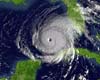
Hurricanes can gain or lose intensity with startling quickness, a phenomenon never more obvious than during the historic 2005 hurricane season that spawned the remarkably destructive Katrina and Rita. Researchers flew through Rita, Katrina and other 2005 storms trying to unlock the key to intensity changes. Now, data from Rita is providing the first documented evidence that such intensity changes can be caused by clouds outside the wall of a hurricane's eye coming together to form a new eyewall. |
|
| The content herein, unless otherwise known to be public domain, are Copyright Space.TV Corporation. AFP and UPI Wire Stories are copyright Agence France-Presse and United Press International. ESA Portal Reports are copyright European Space Agency. All NASA sourced material is public domain. Additional copyrights may apply in whole or part to other bona fide parties. Advertising does not imply endorsement, agreement or approval of any opinions, statements or information provided by Space.TV Corp on any Web page published or hosted by Space.TV Corp. Privacy Statement |