SPACE MART SPACE DAILY SPACE WAR TERRA DAILY MARS DAILY SPACE TRAVEL GPS DAILY ENERGY DAILY
  Space Industry and Business News  
Get Our Free Newsletters Via Email
  
Search All Our Sites at SpaceBank
NMSU Uses Information Collected In Space To Help Those On The Ground

The satellites are constantly orbiting the earth, but without a regional station to collect their data, the information they beam back to earth is lost.
by Staff Writers
Las Cruces NM (SPX) Jun 12, 2008
Farmers looking for the best time to irrigate can get help from weather satellites orbiting the earth on a regular basis. Those same satellites can also help fire fighters battling forest fires and emergency workers trying to understand the scope of a major snow storm.

The only problem - no one in the Southwest was able to collect that data. That was until New Mexico State University's CARSAME program got off the ground.

The Center for Applied Remote Sensing in Agriculture, Meteorology, and Environment (CARSAME) began as a cooperative effort between the U.S. Army Research Laboratory and NMSU's College of Agriculture and Home Economics, Physical Science Laboratory and N.M. Space Grant Consortium.

"We feel we can provide a service, collecting data for other research projects," said Max Bleiweiss, an adjunct professor at NMSU. "Using hydrology modeling, we can account for the water in the Rio Grande Basin. With this satellite data, we can also observe land surface temperatures, monitor dust storms and the growth of vegetation."

The project uses remote sensing stations to collect information from the National Oceanic and Atmospheric Administration's polar orbiting satellites. The satellites scan the earth and send back visible wavebands, middle infrared bands and thermal images. The data is used primarily for meteorological purposes, monitoring the atmosphere and the earth's surface.

The satellites are constantly orbiting the earth, but without a regional station to collect their data, the information they beam back to earth is lost. Other than CARSAME, there are no other collection stations in New Mexico, West Texas, Colorado or Arizona.

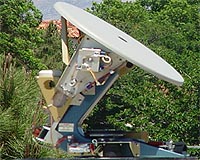
Bleiweiss worked with the remote sensing project beginning more than a decade ago at White Sands Missile Range. After a few years, the U.S. Army Research Laboratory decided to move away from the project, and donated all of the equipment to NMSU. Bleiweiss credits a Ph.D. student in his group, Scott Williams, for putting together the technical aspect of the project.

Before Williams, the antennas were simply sitting as boxes of parts in storage. Williams has two stations, Cumulus and Humilis, up and running. He hopes to have up to three additional antennas online in the future. Williams is currently studying computational agriculture at NMSU.

"What we are seeing is agriculture, along with everything else, going to more computational areas," said Williams. "What I'm trying to do is put a stake in the ground and hopefully attract more researchers and students to this area."

"It's not just agriculture that we are working with at CARSAME," Bleiweiss said. "It's also environmental sciences. With this information, we can study the effects of climate change and see how earlier snowmelt and earlier water runoff affect stream flows."

The group is also working with the National Geospatial-Intelligence Agency and PSL on flashflood modeling and working with UTEP on dust storm modeling and detection. "We are studying how and why these dust storms form so, for example, we can give the Department of Transportation more advanced and accurate information," Bleiweiss said.

CARSAME participates in the Rio Grande Basin Initiative, a partnership between NMSU and Texas A and M University for water conservation along the Rio Grande.

Community
Email This Article
Comment On This Article

Share This Article With Planet Earth
del.icio.usdel.icio.us DiggDigg RedditReddit
YahooMyWebYahooMyWeb GoogleGoogle FacebookFacebook


Related Links
CARSAME
Earth Observation News - Suppiliers, Technology and Application


Aster Images Sichuan Earthquake In China
Greenbelt MD (SPX) Jun 10, 2008
The Sichuan earthquake in China occurred on May 12, 2008, along faults within the mountains, but near and almost parallel the mountain front, northwest of the city of Chengdu. This major quake caused immediate and severe damage to many villages and cities in the area.


Memory Foam Mattress Review

Newsletters :: SpaceDaily Express :: SpaceWar Express :: TerraDaily Express :: Energy Daily
XML Feeds :: Space News :: Earth News :: War News :: Solar Energy News
  • Ships Face Loss Of Broadband Cover
  • Analysis: Crackdown on domain name crooks
  • Pacific students lagging in computer age: researcher
  • Icahn moves to replace Yahoo board, restart Microsoft talks

  • Khrunichev Purchases Majority Interest in International Launch Services
  • Ariane Skynet 5C And Turksat 3A Launch Delayed To June 12
  • Independent Panel To Investigate Ariane 5 Software Glitch
  • GLAST Blast Off Delayed Until At Least June 11

  • China's new jumbo-jet firm no threat to Airbus, Boeing: state media
  • China unveils new jumbo jet company: report
  • NASA And JAXA To Conduct Joint Research On Sonic Boom Modeling
  • Analysis: Can airplanes go green?

  • Harris To Supply Navy Broadband Satellite Terminals
  • Raytheon To Provide Army With New Wideband Receiver Suites
  • Lockheed Martin Team Delivers Flight Software For Next Missile Warning Satellite
  • Keeping The Military Fully Networked And Online

  • Measuring How Much Information There Is In The World
  • Paralysed man takes a walk in virtual world
  • Study finds best times for radio signals
  • Self-Repairing Aircraft Could Revolutionize Aviation Safety

  • Globalstar AppointS Thomas Colby Chief Operating Officer
  • SES AMERICOM Announces Change In Executive Management
  • Bill Flynn Joins Americom Government Services to Lead Navy Programs
  • NASA names science directorate deputy

  • NMSU Uses Information Collected In Space To Help Those On The Ground
  • Aster Images Sichuan Earthquake In China
  • Japanese astronaut says Earth is 'beautiful'
  • A New Satellite Remote Sensing Tool For Improving Agricultural Land Use Observation

  • RMI Alchemy Media Processor Powers NavMate-4 Software
  • New Options For XLi GPS Synchronized Time And Frequency System
  • GPS RADIONOVA M10214 RF Antenna Module Selected For Tranzda's T818 Slim Smart Phone
  • Axway - Blue Vector - Gebhardt Announces Global Track And Trace Alliance

  • The content herein, unless otherwise known to be public domain, are Copyright 1995-2007 - SpaceDaily.AFP and UPI Wire Stories are copyright Agence France-Presse and United Press International. ESA Portal Reports are copyright European Space Agency. All NASA sourced material is public domain. Additional copyrights may apply in whole or part to other bona fide parties. Advertising does not imply endorsement,agreement or approval of any opinions, statements or information provided by SpaceDaily on any Web page published or hosted by SpaceDaily. Privacy Statement