|
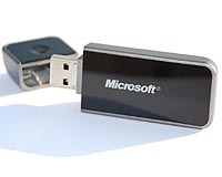
Thalwil, Switzerland (SPX) Aug 29, 2008 u-blox Holding AG has announced that Microsoft has selected its latest positioning engine, u-blox 5, for a new "GPS Locator" USB stick. The "GPS Locator" USB stick will be bundled with the next release of MapPoint, Microsoft's business travel and map software package. The new u-blox 5 GPS chipset is a highly integrated, cost-efficient GPS engine that offers users accurate positioning in a small package without compromising on performance. GPS devices are often bulky and too big to connect to a notebook without a USB cable. With u-blox' innovative u-blox 5 GPS chipset, Microsoft was finally able to overcome this problem, offering users a compact, easy to use GPS-enabled USB stick that feels very much like memory sticks they are used to. The "GPS Locator" USB stick provides users with reliable positioning and a USB 2.0 port for fast and easy data transfer all in one tiny package that easily plugs into any computer. Microsoft expects that this bundled solution, leveraging on Microsoft's leading location software with u-blox' GPS excellence, will further expand the market reach of MapPoint. "We are very proud that Microsoft uses u-blox 5 for its new MapPoint package," said Nikolaos Papadopoulos, President of u-blox America. "The ultra-fast start-up time of the u-blox 5 positioning engine, added to the engine's high sensitivity, as well as cost and space efficiency make it ideal for mass-market applications like Microsoft's innovative MapPoint location product." The 2009 edition of MapPoint with u-blox 5-based "GPS Locator" USB Stick is expected to be on the shelves in August 2008. Related Links u-blox GPS Applications, Technology and Suppliers
 Minneapolis MN (SPX) Aug 27, 2008
XATA has announced it will add improved digital mapping software to its XATANET on-demand fleet operations software. The upgraded mapping software will provide XATANET end-users with more high-quality data, including larger and more dynamic maps, to help better track exact vehicle location and improve route details. |
|
| The content herein, unless otherwise known to be public domain, are Copyright Space.TV Corporation. AFP and UPI Wire Stories are copyright Agence France-Presse and United Press International. ESA Portal Reports are copyright European Space Agency. All NASA sourced material is public domain. Additional copyrights may apply in whole or part to other bona fide parties. Advertising does not imply endorsement, agreement or approval of any opinions, statements or information provided by Space.TV Corp on any Web page published or hosted by Space.TV Corp. Privacy Statement |