Space Industry and Business News  
thincSoft Announces Expanded Integration With Oracle Technology And Applications

thincTrax- an asset visualization solution - interacts with RFID (Radio Frequency Identification), GPS, or other data and provides a visualization and business rules solution for managing critical assets or personnel, location intelligence and situational awareness.
by Staff Writers
Seattle, WA (SPX) Mar 17, 2008
thincSoft has announced an expanded integration with Oracle technology products and solutions. Building on successful implementations of thincVIew integrated with Oracle database, thincSoft has expanded its integration with Oracle products and solutions to include: Oracle WebCenter, Oracle Spatial 10g, Oracle Coherence, Oracle Business Intelligence Enterprise Edition, Oracle Data Warehouse, and Oracle's security solutions including Label Security and Identity Management.

The joint thincSoft/Oracle solution is now deployed at customers in the retail industry as well as within the Department of Defense and U.S. Government sectors.

"We have been very pleased with the short time and effort it has taken to integrate our solution with more and more of the Oracle stack based on customer requests. With our Web 2.0 architecture and Oracle's commitment to industry standards and 'Hot-Pluggable' components, we are able to focus less time on integration and more time on delivering business value to our customers," said thincSoft Chief Operating Officer Jim Kowalski.

Recent market studies indicate that over 80% of data maintained by corporations has a location component. As enterprises start to harness the business value of combining Geographic Information Systems with traditional Business Intelligence data, they combat the challenge of integrating data from multiple sources. thincSoft's thincVIew product is the first to address this growing market need of business data from multiple sources and location content from multiple vendors.
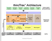
thincSoft
thincSoft is the company that put Business Intelligence and asset tracking on the Map. Their unique product suite combines the best of geospatial visualization with business intelligence and analysis. Simply put, we help our customers visualize their data in ways never before possible, helping them make better decisions. The Web 2.0 platform allows this solution to integrate with any data source and be deployed and interacted with in real time on any thin-client via browser, including hand-held and mobile devices.

Core commercially-available products include:

thincVIew - a Business Intelligence/Location Intelligence application - combines spatial or geospatial data (maps) with business intelligence (BI) data to enable location and time-specific analysis in a unique visualization solution through any portal.

thincTrax- an asset visualization solution - interacts with RFID (Radio Frequency Identification), GPS, or other data and provides a visualization and business rules solution for managing critical assets or personnel, location intelligence and situational awareness.

Related Links
GPS Applications, Technology and Suppliers


Memory Foam Mattress Review
Newsletters :: SpaceDaily :: SpaceWar :: TerraDaily :: Energy Daily
XML Feeds :: Space News :: Earth News :: War News :: Solar Energy News


Modernized GPS Satellite Built by Lockheed Martin Successfully Launched From Cape Canaveral
Cape Canaveral FL (SPX) Mar 16, 2008
A U.S. Air Force modernized Global Positioning System Block IIR (GPS IIR-M) satellite, built by Lockheed Martin, was successfully launched today from Cape Canaveral Air Force Station aboard a United Launch Alliance (ULA) Delta II launch vehicle.


  • Japan marks funeral for second-generation phones
  • Apple iPhone aiming to dethrone BlackBerry
  • Google stock price sinks on Internet ad-slump fears
  • HP And Qualcomm To Deliver Options For Worldwide Internet Access

  • United Launch Alliance Launches Delta 2 For US Air Force GPS Replacement Satellite
  • Russian Proton Rocket Fails To Take Satellite Into Right Orbit
  • United Launch Alliance Inaugural Atlas V West Coast Launch A Success
  • Falcon 1 To Launch Operationally Responsive Space Satellite On Next Flight

  • Aviation industry must act fast on climate change: Airbus chief
  • Northrop, EADS to invest 600 mln dlrs in Alabama site
  • China air passenger traffic up 16.8 percent in 2007: state media
  • Environmentalists climb on Heathrow jet in airport protest: officials

  • Northrop Grumman Ships First Beyond-Line-of-Sight IP Network To US Air Force E-8C Fleet
  • Northrop Grumman Delivers Payload Module For Second Advanced EHF Military Communications Satellite
  • Orbital Awarded Contract For System F6 Satellite Program By DARPA
  • Lockheed Martin Completes Rigorous Test Of First Advanced Military Communications Satellite

  • Artemis Provides Communications For Jules Verne ATV
  • New Discovery At Jupiter Could Help Protect Earth-Orbit Satellites
  • Quasicrystal Mystery Unraveled With Computer Simulation
  • Europe's GEANT computer network extends its reach

  • NASA Names John Shannon New Space Shuttle Manager
  • Michael Larkin Appointed Executive Vice President Of Orbital's Satellite Business Unit
  • Boeing Integrated Defense Systems Looks To Future With Leadership Changes
  • Raytheon Space and Airborne Systems Names Carey VP For ISR Systems

  • Great Splitting Icebergs
  • Falcon Investigates Pollution From The Dakar Metropolis Into Desert Dust Layers
  • NASA Extends Mission For Ball Aerospace-Built ICESat
  • CIRA Scientist Among Authors Of Book Celebrating 50 Years Of Earth Observations From Space

  • Modernized GPS Satellite Built by Lockheed Martin Successfully Launched From Cape Canaveral
  • Alanco StarTrak Announces ReeferTrak Partnership With SkyBitz
  • Maxwell Systems Releases Next Quest Earthwork
  • thincSoft Announces Expanded Integration With Oracle Technology And Applications

  • The content herein, unless otherwise known to be public domain, are Copyright Space.TV Corporation. AFP and UPI Wire Stories are copyright Agence France-Presse and United Press International. ESA Portal Reports are copyright European Space Agency. All NASA sourced material is public domain. Additional copyrights may apply in whole or part to other bona fide parties. Advertising does not imply endorsement, agreement or approval of any opinions, statements or information provided by Space.TV Corp on any Web page published or hosted by Space.TV Corp. Privacy Statement