|
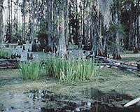
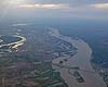
Rolla MO (SPX) Oct 16, 2007 The Mississippi Delta region was losing land long before Hurricane Katrina came ashore. But the correlation between land loss and the risk of flooding in the region is now more evident than ever. The scientific community is not in harmony about what mechanisms are most responsible for the land loss or what to do about it, says Dr. J. David Rogers, the Hasselman Chair of Geological Engineering at the University of Missouri-Rolla. Rogers will present some of his ideas about the land loss problem during the Geological Society of America's annual meeting Oct. 28-31 in Denver. Rogers' presentation, "Geological factors promoting ground subsidence and coastal land loss in the Mississippi Delta and the great debate about what to do about it," starts at 10:30 a.m. Wednesday, Oct. 31, in Room 505 of the Colorado Convention Center. Following the Katrina disaster, Rogers was appointed to the National Science Foundation's Independent Levee Investigation Team. He is also a member of the Coastal Louisiana Recovery Panel, which is charged with making recommendations for a new flood defense system. Among other things, panelists are exploring ways to construct "green levees" by utilizing soil reinforcement technology. "We need to get away from old ideas and systems of defense that have proven unreliable, and try to explore new technologies," Rogers says. "Some of the new infrastructure will be buried beneath the river, and we'll have to be opportunistic in diverting and managing silt-laden flood waters. It's going to require a higher level of management than has previously been applied to the Mississippi River corridor." Rogers is focusing much of his research energy on exploring viable methods to save some of the millions of tons of silt that is being discharged into the Gulf of Mexico instead of being deposited in the Mississippi River's natural flood plain, which covers a third of Louisiana. Since 1950, the delta has been losing an average of 55 square miles of land each year. That figure accelerated to 115 square miles of land loss the day Katrina struck, according to Rogers. In the past 100 years, sea levels have risen about one vertical foot. Scientists estimate that levels will continue to rise between one and three feet per century. Rogers says land loss in the region is caused by many things, including silt deposition, drainage of old swamp and marsh deposits, river management practices for increased navigation, commercial development, and extraction of oil and gas. In Denver, Rogers plans to describe 12 ways in which the Mississippi Delta is sinking and what some of the big ideas are for realistically countering the losses without alienating politicians and direct stakeholders. "Doing nothing isn't an option," Rogers says. "The Mississippi River drains 41 percent of the U.S., and New Orleans exports the largest bulk volume of goods of any port in the world, mostly food. You can't just shut it down. The economic impact would be staggering." Related Links Water News - Science, Technology and Politics
 Cambridge MD (SPX) Oct 16, 2007
A global analysis of the potential effect of climate change on river basins indicates that many rivers impacted by dams or extensive development will require significant management interventions to protect ecosystems and people, according to an article published today in the online version of Frontiers in Ecology and the Environment. |
|
| The content herein, unless otherwise known to be public domain, are Copyright Space.TV Corporation. AFP and UPI Wire Stories are copyright Agence France-Presse and United Press International. ESA Portal Reports are copyright European Space Agency. All NASA sourced material is public domain. Additional copyrights may apply in whole or part to other bona fide parties. Advertising does not imply endorsement, agreement or approval of any opinions, statements or information provided by Space.TV Corp on any Web page published or hosted by Space.TV Corp. Privacy Statement |