|
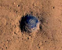
Swindon UK (SPX) Feb 27, 2007 NASA's Mars Reconnaissance Orbiter (MRO) spacecraft has used its onboard High Resolution Imaging Science Experiment camera (HiRISE) to take a colour image of a region of Mars in the vicinity of the intended landing site of Beagle 2. Included in the image is new coverage of the crater H2O which was considered by the Beagle 2 team as unique in the area that had been searched for evidence of the missing Lander. Beagle 2 was targeted to land in an ellipse approximately 50km x 10km in size. The new image does not show any features inside the crater that can be reconciled with peculiarities (i.e. possible components of the entry descent and landing system) encountered in the two previous lower resolution images taken soon after Beagle 2 was due to arrive on Mars in December 2003. The previous images were captured by the Mars Orbiter Camera on NASA's Mars Global Surveyor spacecraft. Commenting on the latest image, Prof Colin Pillinger of the Open University and lead scientist for Beagle 2, said: "Of course this is disappointing. We had hoped that the HiRISE camera would clarify the oddities we had seen in the crater but this is not the case. Nevertheless, I am extremely grateful to the camera team at NASA's Jet Propulsion Laboratory and the University of Arizona for trying and congratulate them on the exceptional quality of the images. I remain optimistic that future images may yet show us where Beagle 2 finally came to rest."
Related Links Particle Physics and Astronomy Research Council Mars Reconnaissance Orbiter HiRoc at Arizona CRISM at APL Mars News and Information at MarsDaily.com Mars News and Information at MarsDaily.com Lunar Dreams and more
 Laurel MD (SPX) Feb 21, 2007
Reaching its first 100 days of operations, the powerful mineral-detector aboard the newest satellite to circle Mars is changing the way scientists view the history of water on the red planet. The Compact Reconnaissance Imaging Spectrometer for Mars (CRISM), designed and built by the Johns Hopkins University Applied Physics Laboratory in Laurel, Md., has teamed with the five other cameras and sensors aboard NASA's Mars Reconnaissance Orbiter (MRO) to provide new clues about where water could have existed on or near the Martian surface. |
|
| The content herein, unless otherwise known to be public domain, are Copyright Space.TV Corporation. AFP and UPI Wire Stories are copyright Agence France-Presse and United Press International. ESA Portal Reports are copyright European Space Agency. All NASA sourced material is public domain. Additional copyrights may apply in whole or part to other bona fide parties. Advertising does not imply endorsement, agreement or approval of any opinions, statements or information provided by Space.TV Corp on any Web page published or hosted by Space.TV Corp. Privacy Statement |