 |
Arlington VA (SPX) Sep 12, 2008 An Air Force Office of Scientific Research-managed team is building a virtual reality environment for the battlespace initiative to maximize the potential of unmanned aerial vehicles. According to Iowa State University lead researcher Dr. James Oliver, the team is applying advanced physical and eye-tracking systems and voice interfaces. "Our goal is to provide role specific interfaces for a team and shared situational awareness using a large display," Dr. Oliver said. The team initially is trying to solve significant human interface issues arising from limitations affecting operators who control UAVs from the ground. They are also designing and testing the hardware, software and aeronautical systems to create immersive ground control stations based on virtual reality technology. "We are using a virtual environment of the battleground as the primary interface context, with the variety of information sources available in a modern military engagement," Dr. Oliver said. "We're also developing and measuring the effectiveness of new human interface techniques, which will enable operators to effectively control multiple, semi-autonomous aircraft. Already, up to 230 persons can be interfaced to participate in the system simultaneously." The virtual reality environment uses a 3-D audiovisual stereoscopic facility, with six walls, 24 projectors, ultrasonic motion tracking, eight-channel audio and a graphics computer. The context has many benefits including large field of view and innovative information representation. The virtual reality environment will enable participants to see the vehicles, the surrounding airspace and the terrain they are flying over as well as information from instruments, cameras, radar and weapons systems. This approach can solve the critical operational and training challenges that must be overcome to allow an operator to simultaneously monitor and control several UAVs at the same time. "We are also exploring new ways to employ virtual reality to address the challenge of time lag that is characteristic of applications where machines are operated at a distance," Dr. Oliver added. Related Links Air Force Office of Scientific Research UAV News - Suppliers and Technology
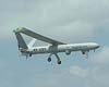 Haifa, Israel (SPX) Sep 09, 2008
Elbit Systems has announced that it was awarded a contract to supply Hermes 450 UAV systems to a country in the Americas for the total of approximately $25 million. The contract also includes Skylark I systems, all to be delivered within a year. |
|
| The content herein, unless otherwise known to be public domain, are Copyright Space.TV Corporation. AFP and UPI Wire Stories are copyright Agence France-Presse and United Press International. ESA Portal Reports are copyright European Space Agency. All NASA sourced material is public domain. Additional copyrights may apply in whole or part to other bona fide parties. Advertising does not imply endorsement, agreement or approval of any opinions, statements or information provided by Space.TV Corp on any Web page published or hosted by Space.TV Corp. Privacy Statement |

