|
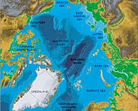
Reston VA (SPX) Sep 10, 2008 A scientific expedition this fall will map the unexplored Arctic seafloor where the U.S. and Canada may have sovereign rights over natural resources such as oil and gas and control over activities such as mining. Both countries will use the resulting data to establish the outer limits of the continental shelf, according to the criteria set out in the Convention on the Law of the Sea. The extended continental shelf, the seafloor and subsoil beyond 200 nautical miles from shore that meet those criteria, is an area of great scientific interest and potential economic development. The expedition will be collaboratively undertaken by the U.S. and Canada using two ships. The U.S. Geological Survey will lead data collection from September 6-October 1 on the U.S. Coast Guard Cutter Healy to map the Arctic seafloor. The Geological Survey of Canada, Natural Resources Canada will follow Healy on the Canadian Coast Guard ship Louis S. St. Laurent (Louis) and study the geology of the sub-seafloor. "The two-ship experiment allows both the U.S. and Canada to collect and share complementary data in areas where data acquisition is costly, logistically difficult, and sometimes dangerous," said USGS scientist Deborah Hutchinson, who will sail aboard Louis. "Both countries benefit through sharing of resources and data as well as increasing likelihood of success by utilizing two ice-breaker ships in these remote areas of the Arctic Ocean." "Healy will utilize an echo sounder, which emits sounds signals in the water, to map the seafloor. This will be done using a multibeam bathymetry system," said USGS scientist Jonathan Childs, chief scientist on Healy during the September cruise. "Unlike conventional echo sounders, which measure the water depth at a point directly beneath the ship, the multibeam system collects a 'swath' of depth information about 3 km wide along the ship's path, creating a three-dimensional view of the seafloor." Related Links United States Geological Survey Convention on the Law of the Sea Beyond the Ice Age
 Ilulissat, Denmark (AFP) Sept 9, 2008
Representatives from the European Union, Canada, Russia, China and South Korea met Tuesday in Greenland to put the spotlight on the Arctic, which is hard hit by global warming and home to vast untapped natural resources. |
|
| The content herein, unless otherwise known to be public domain, are Copyright Space.TV Corporation. AFP and UPI Wire Stories are copyright Agence France-Presse and United Press International. ESA Portal Reports are copyright European Space Agency. All NASA sourced material is public domain. Additional copyrights may apply in whole or part to other bona fide parties. Advertising does not imply endorsement, agreement or approval of any opinions, statements or information provided by Space.TV Corp on any Web page published or hosted by Space.TV Corp. Privacy Statement |