|
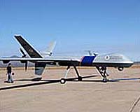
UPI Homeland and National Security Editor Washington (UPI) Feb 12, 2007 The U.S. government is pushing ahead with developing Unmanned Aerial Vehicles, or UAVs, for land border security with Canada. Officials of the U.S. Department of Homeland Security said last week they would work with the Federal Aviation Administration to impose flight restrictions around a North Dakota air base where the new UAV will be tested. "We are working with the FAA to get restrictions on the airspace (above Grand Forks Air Force Base, N.D.) during certain time windows when we fly, typically at night," said Gen. Michael Kostelnik, head of air and marine operations for U.S. Customs and Border Protection, the agency inside the Department of Homeland Security that flies the pilot-less aircraft, known by their military acronym UAV, for Unmanned Aerial Vehicles. The UAV, a version of the military MQ9 Predator B equipped with special cameras and other sensors, and with the ability to stay in the air for up to 30 hours, will be able to monitor remote and inaccessible regions of the border with Canada, officials say. The flight restrictions, which will apply to small planes operating below 18,000 feet, are necessary because of the danger of collisions, but they will draw protests from those who own or fly private planes. The agency currently is flying one Predator B, built by General Atomics Aeronautical Systems, over the south western border, where it uses the already-restricted airspace around Libby Army Air Field at Ft. Huachuca, Ariz. "But there are no restricted or prohibited areas near Grand Forks," points out Heidi Williams, the head of regulatory affairs for the Aircraft Owners and Pilots Association, and the group "would oppose any new restricted airspace created solely for UAV border patrols." Kostelnik, in an interview with United Press International last week said that within three years, Grand Forks would also become the home of a National Guard UAV air wing, flying the less sophisticated Predator A. "We are working with the FAA to help them understand what the implications are of the growing use of UAVs," he said. The homeland security UAV at Grand Forks will also require special FAA certification to fly above 18,000 feet, in so-called Positive Control airspace, through which U.S. air traffic controllers guide commercial flights. Customs and Border Protection will obtain "certificates of authorization to operate (the Predator B) in certain corridors in the national airspace" for the purpose of border patrols, Kostelnik said. He added that the Predator B was "one of the most sophisticated aircraft on the face of the planet," and that it would fly "mainly in the evenings and at night" in places with little existing air traffic. "I'm not interested in flying this thing ... in metropolitan areas," he said. Customs and Border Protection will have four UAVs by the end of the year, he added. The second will join the one already flying in the south west in April, the third will be delivered to Grand Forks by Oct. 1, and the last, delivered by the end of the year, will likely be deployed in a maritime role. He said a prototype drone with sea-view radar would be tested in Florida to assess "its look-down capabilities, (and) its performance against targets we go after down there, and explore interface issues with other (air and marine) assets we have deployed." He said, if the tests were successful, a UAV with a maritime mission might be based on the Gulf coast, Puerto Rico, or San Diego. One drone, a Predator B, was deployed on the south western border in October 2005, where the agency says it contributed to the seizure of four vehicles and over 8,000 pounds of marijuana, before crashing owing to pilot error on April 24, 2006. "There are concerns regarding the high accident rate of UAVs, which is currently 100 times higher than that of manned aircraft," says a Congressional Research Service report from November last year. "Because UAV technology is still evolving," the report continues, "mishap rates are expected to remain high." It goes on to point out, however, that "UAV accidents do not risk the lives of pilots, as do the helicopters that currently patrol U.S. borders." According to the report, the cost of operating a UAV is more than double the cost of operating a manned aircraft, because of the logistical support and specialized pilot and maintenance training required. But Kostelnik said the costs were "not a big issue for us. We are more concerned with the value we get from it." The Congressional Research Service report says the Predator B can fly for 30 hours at a stretch, 15 times as long as a helicopter, and that its cameras can identify an object the size of a milk carton from 60,000 feet. Kostelnik said the UAVs' value would be increased by new technology purchased last year, which will allow them to be flown on both borders via KU-band satellite from the agency's Air and Marine Operations Center in Riverside, Calif. "We will be able to configure the room (from which the drones are flown)... more like the military does" with the potential to sit analysts or experts alongside the operators flying the craft, he said. But he added the ground station would not be delivered until March 2008. "We are in line with a lot of other national users," he said, referring to the Pentagon and U.S. intelligence agencies which are rapidly expanding their use of the Predator. Kostelnik said rapidly rising demand is also creating a shortage of qualified pilots, complicating the agency's pans to take over piloting the craft, which are currently flown by contract pilots from General Atomics.
Source: United Press International Related Links UAV Technology at SpaceWar.com UAV News - Suppliers and Technology
 Tehran (AFP) Feb 10, 2007
Iran said on Saturday it has started mass producing and using a stealth drone with a range of 700 kilometres (420 miles) that it claims is undetectable to radars. "We have built a drone with a more than 700-kilometre range which can collect information and shoot films," the head of the elite Revolutionary Guards, General Yahya Rahim Safavi, told Iran's Arabic-language satellite news channel Al-Alam. |
|
| The content herein, unless otherwise known to be public domain, are Copyright Space.TV Corporation. AFP and UPI Wire Stories are copyright Agence France-Presse and United Press International. ESA Portal Reports are copyright European Space Agency. All NASA sourced material is public domain. Additional copyrights may apply in whole or part to other bona fide parties. Advertising does not imply endorsement, agreement or approval of any opinions, statements or information provided by Space.TV Corp on any Web page published or hosted by Space.TV Corp. Privacy Statement |