|
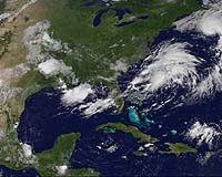
Greenbelt MD (SPX) Aug 01, 2007 The third tropical depression of the Atlantic hurricane season formed around 11:00 p.m. EDT on Monday, July 30 west of Bermuda. Exactly 12 hours later on Tuesday, July 31, at 11:00 a.m. EDT, the storm strengthened into a tropical storm with sustained winds of 40 mph and higher gusts. At that time, the storm was named Tropical Storm Chantal. Chantal was located near latitude 40.2 north and longitude 62.7 west, about 330 miles (530 km) south of Halifax, Nova Scotia and is moving rapidly toward the northeast near 23 mph (37 km/hr). Chantal is not a threat to the United States. Estimated minimum central pressure is 999 millibars, down from 1007 millibars just five hours before on July 31. A drop in pressure is a sign of strengthening. Chantal is the cluster of clouds off the U.S. east coast in the top right side of this satellite image. This image was created with data from the Geostationary Operational Environmental Satellite (GOES-12), on July 31 at 14:30 UTC (10:30 a.m. EDT). GOES-12 is operated by the National Oceanic and Atmospheric Administration. This image was created by NASA's GOES Project Science Office at NASA's Goddard Space Flight Center, Greenbelt, Md.
What do the Forecast Models Show? The National Hurricane Center forecast discussion notes that Chantal is quickly moving into cooler waters, and little additional intensification is expected. Global computer models suggest that Chantal will become the main part of a large powerful low over the northern Atlantic Ocean and a little additional strengthening is shown in a couple days.
Another Atlantic Storm Brewing Elsewhere, forecasters are eyeing an area of low pressure is centered about 700 miles east of the southern windward islands. This system shows some signs of organization...and it has the potential to become a tropical depression in the next couple of days as it moves westward around 15 mph. Credits: Image - NASA GOES Project/NOAA;Summary - Rob Gutro (derived from NHS reports) Goddard Space Flight Center Related Links 2007 hurricane season to date Bringing Order To A World Of Disasters When the Earth Quakes A world of storm and tempest
 Greenbelt MD (SPX) Jul 19, 2007
On Wed. July 18, Tropical Storm Cosme continued its westward trek in the eastern Pacific Ocean, and is expected to pass south of Hawaii over the weekend of July 21-22. At 15:00 UTC (5:00 a.m. Hawaiian Time) on Wed. July 18, the center of Cosme was located near 15.3 north and 138.9 west. The storm was moving west at 12 knots (13 mph), and had maximum sustained winds of 35 knots (40 mph) with gusts to 45 knots (52 mph). Its minimum central pressure was 1004 millibars. |
|
| The content herein, unless otherwise known to be public domain, are Copyright Space.TV Corporation. AFP and UPI Wire Stories are copyright Agence France-Presse and United Press International. ESA Portal Reports are copyright European Space Agency. All NASA sourced material is public domain. Additional copyrights may apply in whole or part to other bona fide parties. Advertising does not imply endorsement, agreement or approval of any opinions, statements or information provided by Space.TV Corp on any Web page published or hosted by Space.TV Corp. Privacy Statement |