Space Industry and Business News  
Tropical Cyclone Nargis Proves Deadly To Myanmar

Credit: NASA/JPL
by Rob Gutro
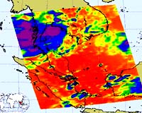
Greenbelt MD (SPX) May 06, 2008
Tropical Cyclone made landfall over the weekend of May 3 and 4 and killed nearly 4,000 people, according to Reuters news service. Thousands more were reported missing. Cyclone Nargis was a Category three storm on the Saffir-Simpson scale of hurricane strength, packing sustained winds of 120 mph when it made landfall.

In the former capital city of Yangon, sturdy buildings suffered damage where roofs are reported to have town off by Nargis' strong winds. The damage in Yangon suggests that the shanty towns outside the city have likely suffered severe damage.

This infrared image of Cyclone Nargis was created on May 4 at 6:29 UTC (2:30 a.m. EDT) by data from the Atmospheric Infrared Sounder (AIRS), an instrument that flies aboard NASA's Aqua satellite.

This AIRS image shows the temperature of the cloud tops or the surface of the Earth in cloud-free regions. The lowest temperatures (in purple) are associated with high, cold cloud tops that make up the top of Nargis (shown as the circular purple area on this satellite image) located over Myanmar.

The infrared signal of the AIRS instrument does not penetrate through clouds. Where there are no clouds the AIRS instrument reads the infrared signal from the surface of the Earth, revealing warmer temperatures (red).

Cyclone Sidr was the last major storm to hit Asia. In November 2007, Sidr killed 3,300 people in Bangladesh.

Related Links
Bringing Order To A World Of Disasters
When the Earth Quakes
A world of storm and tempest


Memory Foam Mattress Review
Newsletters :: SpaceDaily :: SpaceWar :: TerraDaily :: Energy Daily
XML Feeds :: Space News :: Earth News :: War News :: Solar Energy News


Myanmar cyclone kills at least 351
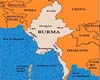
Yangon (AFP) May 4, 2008
At least 351 people were killed and nearly 100,000 left homeless when tropical cyclone Nargis tore through Myanmar, razing thousands of buildings and knocking out power lines, state media said Sunday.


  • Google wins from end of Microsoft-Yahoo affair: analysts
  • Microsoft takeover deadline for Yahoo expires without comment
  • China world's largest Internet market
  • World's Fastest Satellite Internet Connection To User Terminal Via KIZUNA

  • ULA To Launch GRAIL
  • Khrunichev And ILS Announce Quality Initiative
  • Kalam Hails ISRO For Satellite Launch
  • Zenit Rocket Puts Israeli Satellite Into Orbit

  • Analysis: Can airplanes go green?
  • Belgian airline says it will cut costs, emissions by slowing down
  • Airbus, Boeing sign accord to cut air traffic impact on environment
  • Oil spike, cost of planes led to Oasis collapse: founders

  • Northrop Grumman Awarded DARPA Contract To Design Hybrid Optical/RF Communications Network
  • Joint Contracting Command Iraq Selects Proactive Communications For Task Force Iron Project
  • Work Continues On New Satellite Communications Antenna System For B-2 Bomber
  • Raytheon Awarded Contract To Upgrade Satellite Communication Terminals

  • SES ASTRA Starts New Orbital Position At 31.5 Degrees East
  • NASA Ames Partners With m2mi For Small Satellite Development
  • COM DEV Launches Advanced Space-Based AIS Validation Nanosatellite
  • Loral Spins A Giant Web In Space As First ICO Bird Comes Alive

  • NASA names science directorate deputy
  • Northrop Grumman Names Terri Zinkiewicz VP Sector Controller For Its Space Technology Sector
  • Northrop Grumman Appoints Scott Winship To VP And Program Manager - Navy Unmanned Combat Air System
  • NASA Names John Shannon New Space Shuttle Manager

  • Weather Underground Launches Best Weather Map Available On The Internet
  • 4D Ionosphere
  • Subsystems Of Cartosat-2A, IMS-1 Functioning Satisfactorily
  • RADARSAT-2 Commissioned And Ready For Commercial Operation

  • Backpacker Wins National Magazine Award For General Excellence
  • GPS Treasure Hunts Turn Vacations Into High-Tech Adventures
  • MTI Micro Debuts Embedded Fuel Cell Prototype For Handheld GPS Devices
  • Celevoke Appoints The Real Security Company GPS Tracking System Distribution Partner

  • The content herein, unless otherwise known to be public domain, are Copyright Space.TV Corporation. AFP and UPI Wire Stories are copyright Agence France-Presse and United Press International. ESA Portal Reports are copyright European Space Agency. All NASA sourced material is public domain. Additional copyrights may apply in whole or part to other bona fide parties. Advertising does not imply endorsement, agreement or approval of any opinions, statements or information provided by Space.TV Corp on any Web page published or hosted by Space.TV Corp. Privacy Statement