|
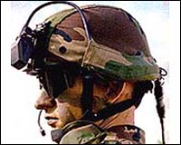
London UK (SPX) Jul 11, 2007 The WBR Soldier Technology Conference in London sees the first public exhibition of MILTRAK, an advanced, compact and lightweight digitised soldier system from Thales UK. MILTRAK will improve the operational effectiveness of front line combat troops by providing commanders with vital situational awareness (SA) information, updated every few seconds. MILTRAK is a simple to use, flexible system comprising of a navigation (NAV) module and a small, ruggedised display for commanders. The total system weight (not including radio) is just 0.5kg. The system is connected to any suitable data capable personal radio, which can transmit and receive positional data. The primary function of the system is to provide SA by displaying the positions of similarly equipped, friendly (blue) forces, overlaid on a relational display, raster map or geo-referenced aerial photograph. Icons clearly indicate the identity and status of troops, significantly improving command and control and making it simple to identify and locate casualties. Navigation is enhanced through the ability to plan, share and follow routes, even where mapping is not available. Simple symbology can be exchanged between commanders, while target hand-offs can be undertaken with the addition of a suitable laser rangefinder. All functions, including adjustment of user selected parameters, are accessed via a simple on-screen menu system making it easy to learn and operate even under stressful conditions. The NAV module contains both civil, and (where authorised) military GPS, a digital magnetic compass and a microprocessor that manages the SA signals. This 310g unit (including batteries) is connected to any suitable voice and data capable UHF or VHF personal radio from the Thales portfolio or from other suppliers. For applications where rifleman are not provided with displays, only the NAV Module and radio are required to automatically transmit own position and status. The fully ruggedised display, normally used by commanders, is connected to the NAV module by fibre-optic cable. The display has a colour screen capable of being read in bright sunlight and can be fitted with a magnified eyecup to eliminate light-spill, thus enabling secure use at night. Fitted with standard AA batteries, the display weighs just 220g. MILTRAK is reliable and robust and designed for use in combat conditions. High availability is facilitated by using proven COTS components, built-in test and minimal maintenance requirements. Its lightweight, small size and simple connectivity allows it to be easily incorporated into legacy load carriage systems. The ease of operation results in a low training load with no requirement for additional equipment. Using experience gained from involvement in a number of international soldier modernisation programmes, Thales is able to offer a comprehensive service to customers including system customisation to meet specific requirements such as integration to legacy equipment and incorporation of national tactics, techniques and procedures. Related Links Thales UK The latest in Military Technology for the 21st century at SpaceWar.com
Plextronics has entered into a three-year cooperative agreement with the U.S. Army Research Laboratory (ARL) to conduct research that will lead to flexible electronic products for soldiers. If funding continues to be available through the Department of Defense over the next three years, the agreement is worth up to $14.2 million. |
|
| The content herein, unless otherwise known to be public domain, are Copyright Space.TV Corporation. AFP and UPI Wire Stories are copyright Agence France-Presse and United Press International. ESA Portal Reports are copyright European Space Agency. All NASA sourced material is public domain. Additional copyrights may apply in whole or part to other bona fide parties. Advertising does not imply endorsement, agreement or approval of any opinions, statements or information provided by Space.TV Corp on any Web page published or hosted by Space.TV Corp. Privacy Statement |