 |
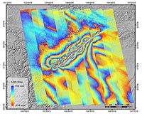
Bonn, Germany (SPX) Oct 22, 2009 The image, acquired by the German radar satellite TerraSAR-X, shows part of the southern Rhine Rift Valley near Freiburg and the city of Staufen (red arrow). To create this image, two separate images that were acquired by the satellite six months apart during 2008 were combined to form what is known as an interferogram. In the built-up area of Staufen, a clear pattern of deformation can be seen. For an initial evaluation of this pattern, two such interferograms were combined; the result is an elevation of the substrata by approximately three centimetres that occurred between January and October 2008. Since September 2007, numerous buildings in Staufen's Old Town have begun to exhibit large cracks that have formed due to the uplift of the substrata. The extent of the damage is considerable and there is no end to the uplift process in sight. A geochemical process called anhydrite swelling has been confirmed as the cause of these uplifts. This is a transformation of the mineral anhydrite (anhydrous calcium sulphate) into gypsum (hydrous calcium sulphate). A pre-condition for this transformation is that the anhydrite is in contact with water, which is then stored in its crystalline structure. This absorption of water causes the anhydrite to increase in volume by around 60 per cent, leading to the observed uplifts and the associated damage to the buildings in Staufen.
Possible causes of the elevation Another cause could be the geothermal energy drilling that was carried out in the late summer of 2007, which may have destroyed a natural barrier layer between the groundwater and the anhydrite deposit, making contact between them possible. TerraSAR-X project scientists and industry are currently carrying out detailed studies on the cause, progression and effects of the anhydrite swelling.
The TerraSAR-X mission The satellite travels around Earth in a polar orbit and records unique, high-quality X-band radar data about the entire planet using its active antenna. TerraSAR-X works regardless of weather conditions, cloud cover or the absence of daylight and is able to provide radar data with a resolution of down to one metre. DLR is responsible for using TerraSAR-X data for scientific purposes. It is also responsible for planning and implementing the mission as well as controlling the satellite. Astrium built the satellite and shares the costs of developing and using it. Infoterra GmbH, a subsidiary company founded specifically for this purpose by Astrium, is responsible for marketing the data commercially. Share This Article With Planet Earth
Related Links German Aerospace Center (DLR) Earth Observation News - Suppiliers, Technology and Application
 Satellite Data Look Behind The Scenes Of Deadly Earthquake
Paris, France (ESA) Oct 16, 2009 Using satellite radar data and GPS measurements, Chinese researchers have explained the exceptional geological events leading to the 2008 Wenchuan Earthquake that killed nearly 90 000 people in China's Sichuan Province. "One of the very fundamental issues for understanding an earthquake is to know how the rupture is distributed on the fault plane, which is directly related to the amount of ... read more |
|
| The content herein, unless otherwise known to be public domain, are Copyright 1995-2009 - SpaceDaily. AFP and UPI Wire Stories are copyright Agence France-Presse and United Press International. ESA Portal Reports are copyright European Space Agency. All NASA sourced material is public domain. Additional copyrights may apply in whole or part to other bona fide parties. Advertising does not imply endorsement,agreement or approval of any opinions, statements or information provided by SpaceDaily on any Web page published or hosted by SpaceDaily. Privacy Statement |
 del.icio.us
 Digg
Digg Reddit
 YahooMyWeb
 Google