|
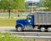
Cary IL (SPX) Dec 17, 2008 The existence of a GPS tracking unit in a fleet vehicle proved to be doubly advantageous when the truck was recovered on the same day after being stolen from the company's lot. Three months ago, Todd Blackburn, Vice-President of Sales for CEIS/TECHSICO had the LandAirSea 8100 GPS tracking system installed in all 25 of the company's fleet trucks, primarily as a means of tracking their drivers' mileage and travel routes. What he hadn't actively considered was the possibility of auto theft and the role of the 8100 unit in the vehicle's recovery. The L.A.S. (LandAirSea) 8100 device is a GPS tracking system designed to accurately determine the exact location of a vehicle in "real time." Used either as a portable device operating on an internal lithium battery pack or connected directly to the vehicle's 12 volt power supply, the 8100 unit can be set to update its location from every second up to 30 minutes and anywhere in between. Its hardware and software are designed for use in both single unit portable applications or large fleet management installations, such as CEIS/TECHSICO's. In Tulsa, Oklahoma, on the morning of Wednesday, October 15th, a vehicle was reported stolen from the company's parking lot. By changing the frequency of the 8100 unit's updating to second-by-second intervals, Blackburn was able to view the thief's route on Google Earth. Within just hours of its disappearance, the stolen vehicle was recovered undamaged. "The LandAirSea 8100 unit was initially purchased as a productivity tool to track mileage," said Blackburn. "We are pleased to have been able to use this product to retrieve a valuable company asset as well." Related Links LandAirSea GPS Applications, Technology and Suppliers
 Denver CO (SPX) Dec 17, 2008
Intermap Technologies have announced that it has entered into a partnership agreement with Lowrance, a leader in outdoor navigation and wholly-owned brand of Navico Holding AS to offer AccuTerra maps for the Brand's enhanced outdoor GPS devices. |
|
| The content herein, unless otherwise known to be public domain, are Copyright Space.TV Corporation. AFP and UPI Wire Stories are copyright Agence France-Presse and United Press International. ESA Portal Reports are copyright European Space Agency. All NASA sourced material is public domain. Additional copyrights may apply in whole or part to other bona fide parties. Advertising does not imply endorsement, agreement or approval of any opinions, statements or information provided by Space.TV Corp on any Web page published or hosted by Space.TV Corp. Privacy Statement |