Space Industry and Business News  
Start of ALOS Kyoto And Carbon Initiative By The ALOS Daichi

Deforestation in Brazil (Mato Grosso). Blackened areas indicate deforestation.
by Staff Writers
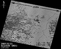
Tokyo, Japan (JAXA) Sep 07, 2007
The Japan Aerospace Exploration Agency (JAXA) has been working on the establishment of the "ALOS Kyoto and Carbon Initiative"*1 since 2003. The Initiative is being carried out as cooperative research with 20 international research institutions including the University of California Santa Barbara (UCSB,) USA. On August 23, 2007, we finalized the conclusion of the agreements with all 20 international research institutions following the signing of Brazilian Institute of Environment and Renewable Resources (IBAMA.) With the completion, we began our full-scale operation of the project on September 3.

JAXA and IBAMA will specify the area of deforestation including illegal activities using images acquired by the onboard equipment "PALSAR"2 of the "Daichi."

ALOS Kyoto and Carbon Initiative
The purpose of this project is to study the relationship between changes in the global environment and changes in forests, their surrounding areas, swamplands and deserts, which account for about 30% of the global land area, by observing their long-term and seasonal changes in a broad scope through the onboard synthetic aperture radar of the "Daichi." The study is based on the analysis of the observation data as well as a site survey. For this purpose, JAXA will carry out global observations including on tropical rain forests in South America (Amazon,) Southeast Asia, and Central Africa, and the boreal forests in Siberia, Canada, and Alaska. Acquired data will be transmitted to each institution via exclusive online networks within three months after it is received at the Earth Observation Center (Hatoyama-machi, Saitama) of JAXA. In the case of data from the Amazon area, it is converted to images immediately, and provided to the IBAMA within 10 days.

PALSAR
The Phased Array type L-band Synthetic Aperture Radar (PALSAR), is a microwave sensor receiving radio wave reflections transmitted from the satellite. It can acquire image data regardless of the weather and time of day. One of the characteristics of the L-band microwave is that it can partially penetrate through a forest to the ground; therefore, it is suitable to observe a lower part of a forest.

Related Links
Japan Aerospace Exploration Agency (JAXA)
Climate Science News - Modeling, Mitigation Adaptation


Memory Foam Mattress Review
Newsletters :: SpaceDaily :: SpaceWar :: TerraDaily :: Energy Daily
XML Feeds :: Space News :: Earth News :: War News :: Solar Energy News


China leads charge against Australian climate pact
Sydney (AFP) Sept 6, 2007
Australia's plans for a strong statement by Asia Pacific leaders on climate change fell into disarray Thursday as emerging nations led by China insisted the United Nations must retain the upper hand.


  • Digital Dandelions: The Flowering Of Network Research
  • Researchers Aim To Make Internet Bandwidth A Global Currency
  • Controlling Bandwidth In The Clouds
  • Broadband revolutionizes education on remote Maldives atolls

  • Russian Proton-M Rocket With Japanese Satellite Crashes On Launch
  • JCSAT-11 Satellite Ready For Launch From Baikonur
  • ISRO Plans More Launches, INSAT-4CR In Good Health
  • India launches communications satellite

  • Asia's largest airshow to ride on China's wings
  • Brazil's TAM Airlines Orders 1,000th Boeing 777
  • Progress On The Hornet Capability Upgrade
  • Thompson Files: F-35 engine follies

  • Northrop Grumman Receives Major Contract For Guardrail Modernization
  • Boeing Demonstrates FAB-T Interoperability With Milstar Satellite
  • Boeing Awarded US Air Force Contract For Combat Survivor Evader Locator Radios
  • BAE Systems To Develop Electronic Warfare Amplifier Technology

  • Russian Satellites: Smaller, Lighter, Cheaper
  • INSAT-4CR Raised To A Perigee Of 15994 Kilometers
  • Sharp unveils ultra-sensitive touch-screen LCD
  • Boeing Demonstrates Future On-Orbit Servicing Capability With Orbital Express

  • Raytheon Names Dr. Thomas Kennedy VP Tactical Airborne Systems
  • Northrop Grumman Appoints James Myers VP And GM Of Navigation Systems Division
  • Senior Official Of Energia Space Appointed President
  • New SIDC Commander Has The Wright Stuff

  • Key Sensor For Northrop Grumman NPOESS Program Passes Critical Structural Test
  • Air France And ESA Join To Offer Passengers Unique View Of Voyage
  • NASA Scientist Treks To Burning Man Festival
  • European Hot Spots And Fires Identified From Space

  • Lockheed Martin Team Shifts Into Production Effort To Add GPS Demonstration Signal To Modernized Satellite
  • India To Build Constellation Of Seven Navigation Satellites
  • Lockheed Martin Bids On Next Generation Global Positioning Satellite System
  • Boeing Bids On Next Generation Global Positioning Satellite System

  • The content herein, unless otherwise known to be public domain, are Copyright Space.TV Corporation. AFP and UPI Wire Stories are copyright Agence France-Presse and United Press International. ESA Portal Reports are copyright European Space Agency. All NASA sourced material is public domain. Additional copyrights may apply in whole or part to other bona fide parties. Advertising does not imply endorsement, agreement or approval of any opinions, statements or information provided by Space.TV Corp on any Web page published or hosted by Space.TV Corp. Privacy Statement