Space Industry and Business News  
Spacecraft Tandem Provides New Views Of Venus

For more images and animations please go here.
by Staff Writers
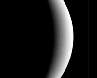
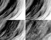
Washington DC (SPX) Jul 20, 2007
NASA's Mercury Surface, Space Environment, Geochemistry, and Ranging spacecraft, known as Messenger, and the European Space Agency's Venus Express recently provided the most detailed multi-point images of the Venusian atmosphere ever seen. The images result from a June 5 flyby of Venus by Messenger during its long journey to Mercury. Venus Express already was in orbit at the planet. The two spacecraft carry sets of instruments employing different observation techniques that complement each other.

Messenger made its closest approach to Venus at a distance of approximately 210 miles on the night side of the planet. At the same time, Venus Express was behind the horizon, almost above the planet's South Pole, at approximately 21,750 miles.

Scientists from both missions are continuing analysis of the images and accompanying data. Data included several instruments studying Venus' cloud deck and surface, plasma environment, magnetic fields, and atmosphere. More results from this joint observation campaign are expected by the end of the year.

Messenger launched on Aug. 3, 2004, and swung by Venus first on Oct 24, 2006, and for the second time in June. Messenger will enter Mercury's orbit in March 2011. Venus Express, the European Space Agency's first mission to Venus, launched on Nov. 9, 2005, and reached the planet on April 11, 2006.

Related Links
Messenger
Venus Express News and Venusian Science


Memory Foam Mattress Review
Newsletters :: SpaceDaily :: SpaceWar :: TerraDaily :: Energy Daily
XML Feeds :: Space News :: Earth News :: War News :: Solar Energy News


Venusian Rendezvous Results: Chapter One
Paris, France (ESA) Jul 16, 2007
ESA's Venus Express and NASA's MESSENGER booked an appointment at Venus late in the evening of 5 June, to look at the oddities of this mysterious planet in tandem for a few hours. Just a few weeks on, scientists from both teams are ready to present a first set of images.


  • Vizada Launches SkyFile Access For Better Mobile Satellite Data Transfer
  • Bringing Mobile Cellular Phones To The Skyways
  • Rockwell Collins And ARINC Sign Agreement For Broadband Offering
  • Academic Group Releases Plan To Share Power Over Internet Root Zone Keys

  • Spaceway 3 Is Delivered To The Spaceport For Its Mid-August Ariane 5 Launch
  • Russian Space Firm Signs 14 Deals For Commercial Rocket Launches
  • Sea Launch To Resume Zenit Launches In October
  • Russia Proton-M Booster Puts US Satellite Into Orbit

  • Sensors May Monitor Aircraft For Defects Continuously
  • Goodrich Contributes Technology For Environmentally-Friendly Engine Research Program
  • Sukhoi Super Jet: The Great White Hope Of The Russian Aircraft Industry
  • Sarkozy, Merkel To Tackle Airbus Problems

  • ViaSat Wins Order In MIDS Tactical Network Terminal Lot 8 Award
  • A-10s Get Digital Makeover
  • TSAT Team Demonstrates Technology Maturity Of Laser Communications Subsystem
  • Boeing Showcases Operational TSAT System During Critical Review

  • Nature's Secrets Yield New Adhesive Material
  • Smart Fabric Biosensors Will Monitor Respiration Rate And Body Temperature In Real Time
  • BAE Systems To Produce Field Programmable Gate Array For Space Use
  • Researchers Develop Tool For Clearer Ultrasound Images

  • New SIDC Commander Has The Wright Stuff
  • NASA Administrator Names Ryschkewitsch As New Chief Engineer
  • Hall Appoints Feeney To Top GOP Position On Space And Aeronautics Subcommittee
  • Dodgen Joins Northrop Grumman As Vice President Of Strategy For Missile Systems Business

  • NASA Awards Contract For Land-Imaging Instrument
  • GOP House Science Committee To Evaluate NASA Earth Science Budget
  • Subcommittee Continues Look At Status of NASA Earth Science Programs
  • QuikSCAT Marks Eight Years On-Orbit Watching Planet Earth

  • Helicopter Flight Trials For EGNOS
  • Boeing To Submit Proposal For Global Positioning System 3
  • Pseudo-Satellites Allow Accurate Navigation In Helsinki Harbour
  • Cooperation Agreement For Satellite Navigation In Africa

  • The content herein, unless otherwise known to be public domain, are Copyright Space.TV Corporation. AFP and UPI Wire Stories are copyright Agence France-Presse and United Press International. ESA Portal Reports are copyright European Space Agency. All NASA sourced material is public domain. Additional copyrights may apply in whole or part to other bona fide parties. Advertising does not imply endorsement, agreement or approval of any opinions, statements or information provided by Space.TV Corp on any Web page published or hosted by Space.TV Corp. Privacy Statement