|
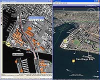
San Diego CA (SPX) Jul 19, 2007 A new version of BAE Systems' image analysis and mapping software enables analysts to evaluate and share intelligence data more effectively by integrating with Google Earth and the ESRI geodatabase. SOCET GXP v2.3 interacts with Google Earth in real time for quick, 3D color visualization and gives geospatial context to objects of interest, resulting in enhanced intelligence for mission planning. With additional tools for detecting changes from one day to the next, analysts can anticipate conditions such as rough terrain or collapsed bridges and pinpoint operational routes more accurately. It also provides a direct connection to the ESRI geodatabase, the Environmental Systems Research Institute's common data storage and management framework. Connection with the database allows users to work with data over secure networks for accurate, timely analysis. "Out in the field, where SOCET GXP is used to make quick decisions, efficiency and accuracy are crucial," said Dan London, BAE Systems' vice president for Geospatial eXploitation Products. "With the integration of Google Earth and ESRI database, SOCET GXP transforms data into usable intelligence." The SOCET GXP upgrade enables analysts to use familiar tools and universal file formats to edit, store, and retrieve information, avoiding time-consuming searches for hard-copy reports. The application also supports the National Geospatial-Intelligence Agency's Spatially Enabled Exploitation initiative to standardize image data formats for optimal information sharing across global networks. The application produces image graphics - such as roads, buildings, and targets - using a ground coordinate system that records latitude, longitude, and elevation data, eliminating the need for manual registration. Related Links BAE Systems Military Space News at SpaceWar.com
 New Delhi, India (RIA Novosti) Jul 19, 2007
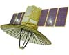
A leading Indian broadsheet quoted anonymous sources Wednesday as saying the country is planning to launch an Israeli spy satellite in September. According to information obtained by Times of India, the Indian Space Research Organization's (ISRO) time-proven four-stage Polar Satellite Launch Vehicle will carry a 260-kg satellite named TechSar from the Sriharikota space centre, on island off India's southern coast. The launch will cost around $15 million. |
|
| The content herein, unless otherwise known to be public domain, are Copyright Space.TV Corporation. AFP and UPI Wire Stories are copyright Agence France-Presse and United Press International. ESA Portal Reports are copyright European Space Agency. All NASA sourced material is public domain. Additional copyrights may apply in whole or part to other bona fide parties. Advertising does not imply endorsement, agreement or approval of any opinions, statements or information provided by Space.TV Corp on any Web page published or hosted by Space.TV Corp. Privacy Statement |