|
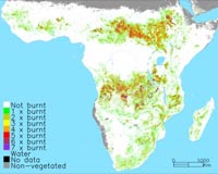
Leicester, UK (SPX) May 28, 2008 A geographer from the University of Leicester has produced for the first time a map of the scorched Earth for every year since the turn of the Millennium. Dr Kevin Tansey, of the Department of Geography, a leading scientist in an international team, created a visual impression of the fire scars on our planet between 2000 and 2007. The work was funded by the Joint Research Centre of the European Commission. The map reveals that between 3.5 and 4.5 million km2 of vegetation burns on an annual basis. This is an area equivalent to the European Union (EU27) and larger than the country of India that is burnt every year. The information is vital for scientists and agencies involved in monitoring global warming, measuring and understanding pollutants in the atmosphere, managing forests and controlling fire and even for predicting future fire occurrence. The research has been published in the journal Geophysical Research Letters. Dr Tansey, a Lecturer in Remote Sensing at the University of Leicester, said: "We have produced, for the first time, a global data base and map of the occurrence of fire scars covering the period 2000-2007. Prior to this development, data were only available for the year 2000. With seven years of data, it is not possible to determine if there is an increasing trends in the occurrence of fire, but we have significant year-to-year differences, of the order of 20%, in the area that is burnt. "The work was undertaken with colleagues from the Joint Research Centre of the European Commission (Italy) and the Universite catholique de Louvain (Belgium). "This unique data set is in much demand by a large community of scientists interested in climate change, vegetation monitoring, atmospheric chemistry and carbon storage and flows. "We have used the VEGETATION instrument onboard the SPOT European satellite, which collects reflected solar energy from the Earth's surface, providing global coverage on almost a daily basis. "When vegetation burns the amount of reflected energy is altered, long enough for us to make an observation of the fire scar. Supercomputers located in Belgium were used to process the vast amounts of satellite data used in the project. At the moment, we have users working towards predicting future fire occurrence and fire management issues in the Kruger Park in southern Africa". "The majority of fires occur in Africa. Large swathes of savannah grasslands are cleared every year, up to seven times burnt in the period 2000-2007. The system is sustainable because the grass regenerates very quickly during the wet season. "From a carbon perspective, there is a net balance due to the regenerating vegetation acting as a carbon sink. Fires in forests are more important as the affected area becomes a carbon source for a number of years. "The forest fires last summer in Greece and in Portugal a couple of years back, remind us that we need to understand the impact of fire on the environment and climate to manage the vegetation of the planet more effectively. "Probably 95% of all vegetation fires have a human source; crop stubble burning, forest clearance, hunting, arson are all causes of fire across the globe. Fire has been a feature of the planet in the past and under a scenario of a warmer environment will certainly be a feature in the future". Related Links University of Leicester Forest and Wild Fires - News, Science and Technology
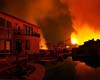 Miami (AFP) May 13, 2008
Firefighters in Florida are battling wildfires Tuesday that have engulfed thousands of acres (hectares) along the southern state's central Atlantic coast, ravaging dozens of homes and shutting down major thoroughfares. |
|
| The content herein, unless otherwise known to be public domain, are Copyright Space.TV Corporation. AFP and UPI Wire Stories are copyright Agence France-Presse and United Press International. ESA Portal Reports are copyright European Space Agency. All NASA sourced material is public domain. Additional copyrights may apply in whole or part to other bona fide parties. Advertising does not imply endorsement, agreement or approval of any opinions, statements or information provided by Space.TV Corp on any Web page published or hosted by Space.TV Corp. Privacy Statement |