|
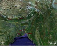
Washington (AFP) Feb 19, 2009 A team of US scientists led by Purdue University unveiled an interactive Google Earth map on Thursday showing carbon dioxide emissions from fossil fuels across the United States. The high-resolution map, available at purdue.edu/eas/carbon/vulcan/GEarth/, shows carbon dioxide emissions in metric tons in residential and commercial areas by state, county or per capita. Called "Vulcan" after the Roman god of fire, the project, which took three years to complete, quantifies carbon dioxide emissions from burning fossil fuels such as coal and gasoline. It breaks down emissions by the sectors responsible including aircraft, commercial, electricity production, industrial, residential and transport. "This will bring emissions information into everyone's living room as a recognizable, accessible online experience," said Kevin Gurney, the project leader and an assistant professor of earth and atmospheric sciences at Purdue. "We hope to eventually turn it into an interactive space where the public will feed information into the system to create an even finer picture of emissions down to the street and individual building level," he added. The United States accounts for some 25 percent of global emissions of carbon dioxide, which scientists have identified as the most important human-produced gas contributing to global climate change. Simon Ilyushchenko, an engineer at Internet search giant Google who worked on the project, said "integrating the data with Google Earth was a way to advance public understanding of fossil fuel energy usage. "Dynamic maps of the data, broken down by the different sources of emissions, easily show where people burn more gasoline from driving or where they use more fuel for heating and cooling homes and businesses," he said. Vulcan integrates carbon dioxide emissions data from the US Environmental Protection Agency and US Department of Energy. The current data is from 2002, but the scientists said they plan to incorporate more recent data. Besides Purdue, the project also involved researchers from Colorado State University and Lawrence Berkeley National Laboratory. It was funded by NASA, the US Department of Energy, the Purdue Showalter Trust and Indianapolis-based Knauf Insulation. Related Links Climate Science News - Modeling, Mitigation Adaptation
 Washington DC (UPI) Feb 18, 2009
The new head of U.S. intelligence and top adviser to President Barack Obama says climate change is a top threat to the national security of the country. |
|
| The content herein, unless otherwise known to be public domain, are Copyright Space.TV Corporation. AFP and UPI Wire Stories are copyright Agence France-Presse and United Press International. ESA Portal Reports are copyright European Space Agency. All NASA sourced material is public domain. Additional copyrights may apply in whole or part to other bona fide parties. Advertising does not imply endorsement, agreement or approval of any opinions, statements or information provided by Space.TV Corp on any Web page published or hosted by Space.TV Corp. Privacy Statement |