|
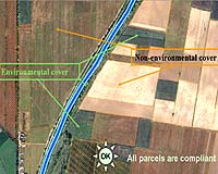
Paris, France (SPX) Apr 16, 2007 An ESA-backed project has demonstrated how Earth observation satellites can assist in the cross compliance measures - a set of environmental and animal welfare standards that farmers have to respect to receive full funding from the European Union - included in the 2003 reforms of the Common Agricultural Policy. Using very high resolution (VHR) satellite images for monitoring whether land is safeguarded in Good Agricultural and Environmental Condition (GAEC), as outlined within the cross-compliance framework, ensures subsidies are distributed in a fair and timely manner and helps farmers complete subsidy applications more accurately. High resolution satellites as well as aerial photography have been used for some time to monitor areas where subsidies are provided. VHR Earth observation (EO) satellites, however, offer more detail compared with HR satellites and are capable of identifying various landscape features and detecting potential erosion, tillage practices and maintenance of pastures. Under the GAEC standards implemented in some countries, farmers cannot remove certain landscape features, including hedges, tree rows, water ponds, walls and single trees, without authorisation of national administration in order to preserve habitats for different organisms and species. By using special classification procedures on VHR satellite images, identification of these landscape features is possible. In combination with digital aerial images, even single trees can be delineated. By comparing older and recent images of these same areas with the processed 'reference landscape feature' layer, the removal of these features can be detected. To protect soils against erosion risks and improve soil structure, the GAEC as applied in some countries, states farmers must establish an 'environmental cover' for a buffer width, stipulated by the country itself (e.g. 5 metres), around waterways on all parcels adjacent to waterways to restrict diffuse pollution in waters and soils. Pastures, permanent crops, woods, hedges and paths are considered 'environmental cover', while mainly arable land and crops are not. Because satellite images allow for the interpretation of agricultural parcels, compliancy can be easily detected. Photo interpretation by remote sensing speeds up the process and allows many parcels to be checked in one time. Tillage practices are also important for reducing erosion as they can reduce the runoff of water across the land surface. The GAEC stipulates that farmers have to plough or plant parallel to contour lines to avoid erosion on slopes more than or equal to a certain percentage defined by the country (e.g. slope of 10 percent). By detecting parcels within this slope range, detecting the slope direction and the ploughing or planting direction, it is possible to calculate the angle between the slope and ploughing direction, taking into account the soil-sensitivity to erosion, and determine whether the farmer is compliant. In order to receive subsidies for permanent crops, the GAEC requires that farmers properly maintain them. Using VHR images, the distinction between crops that are 'maintained good' and crops that are 'possibly maintained badly' can be detected, allowing authorities to visit the fields in question to detect whether they are abandoned or neglected. This project was funded by ESA's Earth Observation Market Development (EOMD) programme, aimed at fostering the development of EO data within business practices, and carried out by EUROSENSE, a company that specialises in remote sensing. Related Links EUROSENSE Common Agricultural Policy (CAP) Earth Observation Market Development The latest farming technology and science news Farming Today - Suppliers and Technology
 Beijing (AFP) April 09, 2007
China's farmland is becoming increasingly polluted, with coal-dependent factories and polluted waterways causing billions of dollars in damages, state press reported Monday. Heavy metals contaminate 12 million tonnes of grains each year, leading to direct losses of more than 20 billion yuan (2.6 billion dollars), the China Daily said, citing the nation's environmental watchdog. |
|
| The content herein, unless otherwise known to be public domain, are Copyright Space.TV Corporation. AFP and UPI Wire Stories are copyright Agence France-Presse and United Press International. ESA Portal Reports are copyright European Space Agency. All NASA sourced material is public domain. Additional copyrights may apply in whole or part to other bona fide parties. Advertising does not imply endorsement, agreement or approval of any opinions, statements or information provided by Space.TV Corp on any Web page published or hosted by Space.TV Corp. Privacy Statement |