|
Stockholm, Sweden (SPX) Oct 17, 2008 Counter-terrorist teams from six European countries has used Saab command and control and training systems in a large-scale homeland security exercise. The NEMO 2008 exercise, hosted by Sweden and taking place among the islands in the archipelago east of Stockholm, was organised under the umbrella of ATLAS, the federation of European police counter-terrorist units that aims to bring the same high levels of competence, knowledge and expertise to bear on the issues surrounding responses to terrorism and serious organised crime. Throughout the planning and rehearsal phase of the exercise, as well as during implementation, crack police teams from Belgium, Denmark, Germany, the Netherlands, Spain and Sweden used the Wearable Command Unit (WCU), developed by Saab Systems, to share data, communications, intelligence and planning materials. The exercise culminated in a coordinated assault by helicopter and rapid RIB boats on the ferry Silja Symphony, which under the exercise scenario had been captured by an estimated 20-40 terrorists, who had killed at least ten hostages and were holding almost 200 more. During the assault, the various national police teams wore vests and other elements of Saab Training Systems' Gamer Manpack distributed training system. NEMO 2008 was considered to be the first large-scale exercise of its type ever conducted by international police forces. The combination of the Saab WCU command and control system, Saab Training Systems' proven distributed laser-based training system and a significant number of video cameras integrated into the on-board instrumentation provided the authorities with a crystal clear view of the potential benefits of this type of training. "We have gained valuable additional experience with the WCU - which we have been using for over a year - and can see many potential benefits coming from the training system," said Bertil Olofsson, Superintendent of the counter-terrorist unit in Sweden's Rikskriminalpolisen (National Criminal Police)." Despite having little more than one hour in which to instrument the ferry prior to the start of the exercise, Saab's systems provided a seamless, integrated service in very complex and challenging conditions. The video cameras, integrated into the instrumentation for the first time on this scale, provided full motion video coverage of the assault events, in real time, to an international audience of police and security agency chiefs viewing the assault from a remote location. "We achieved our objectives for this exercise and we learned a great deal about how we can contribute to further development of this type of collaborative training," said Johan Olander, director of civil security programmes at Saab Training Systems. As well as being supported by the member and observer nations of the ATLAS community, NEMO 2008 attracted considerable governmental and political interest and support. Swedish Minister of Justice Beatrice Axe was present throughout the exercise and was unstinting in her support of its objectives. "Discussion at [national and international] Ministerial level have made it very clear that we all agree on the importance of collaborative training of this nature and on this type of scale. There will always be situations in which some of us might find it impossible to act effectively on our own. In my opinion, therefore, it is better to ask one's national team to collaborate when the need arises. Which means we need to know how to cope with such circumstances - and how to prepare for them," she said. Related Links Saab Naval Warfare in the 21st Century
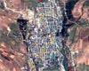 Washington DC (SPX) Oct 14, 2008
Satellite images captured before and after the 7-8 August clash between Georgia, South Ossetian separatists and Russia reveal that 424 civilian structures near Tskhinvali were damaged by 19 August - although they appeared intact in images taken on 10 August and earlier, the American Association for the Advancement of Science (AAAS) has reported. |
|
| The content herein, unless otherwise known to be public domain, are Copyright Space.TV Corporation. AFP and UPI Wire Stories are copyright Agence France-Presse and United Press International. ESA Portal Reports are copyright European Space Agency. All NASA sourced material is public domain. Additional copyrights may apply in whole or part to other bona fide parties. Advertising does not imply endorsement, agreement or approval of any opinions, statements or information provided by Space.TV Corp on any Web page published or hosted by Space.TV Corp. Privacy Statement |