|
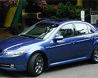
Geneva, Switzerland (SPX) Oct 22, 2008 STMicroelectronics has announced an agreement with NAVTEQ to collaborate on the development of a novel solution that combines a digital road map with positioning data to enable advanced driver assistance applications, such as curve over-speed warning or adaptive headlight control. Embedded in a small, low-cost module, the Map and Positioning Engine (MPE) is designed to enhance driver safety and convenience in all vehicles, even when a driver navigation system is not resident. Because traffic accidents can result from driving too fast when navigating curves, systems capable of warning and aiding the driver in keeping a safe speed look very promising. Knowing distance to an upcoming curve and the curve's radius, the ST engine with a NAVTEQ MPE map can enable applications that calculate a maximum speed to safely pass the curve and, if the vehicle's speed exceeds this limit, warn the driver -- visually, acoustically, or haptically -- or even reduce the speed automatically. Similarly, the MPE can enable applications that generate a warning message or prevent acceleration by the adaptive cruise control when the vehicle is in a freeway exit lane, in a speed-limited urban area, or approaching traffic lights over the next hill. The key elements of the MPE are ST's GPS technology and the NAVTEQ MPE map containing ADAS road geometry, topology, and additional attributes, such as number of lanes or speed limits. The current vehicle position is matched to upcoming road segments in the map and NAVTEQ's patented Electronic Horizon technology interprets attributes on the road ahead to deliver essential predictive road information that could warn or aid the driver in advance of a potentially dangerous situation. The powerful, cost-effective design can be implemented in a small module about the size of a credit card that would operate on the vehicle's CAN (Controller Area Network) bus or even embedded in another sensor or electronic control unit in the car. Such autonomy will allow developers to deploy critical ADAS (Advanced Driver Assistance Systems) applications independent of standard vehicle navigation systems. "We are very excited to be working with ST and their proven GPS technology on this important industry development," said Bob Denaro, NAVTEQ vice president of ADAS. "ST has done a masterful job of implementing our Map and Positioning Engine and realizing our vision of bringing the critical efficiency, safety and convenience features to all vehicles." "The ability to provide predictive road information and help both the driver and vehicle better react to current conditions represents a quantum leap in thinking about digital maps and GPS positioning in the car," said Kevin Gagnon, Vice President of STMicroelectronics' Automotive Business Unit. "We are pleased to play a key role in the development of NAVTEQ-initiated platform that is set to foster rapid deployment of ADAS applications independent of the vehicle's installed navigation system." Additional enhancements to driver safety that could benefit from the combination of real-time positioning data and the digital map include adaptive headlight control and optimized slope driving. For example, when the vehicle is approaching a curve, the headlights can be turned exactly into the direction the vehicle will go, even before the curve is reached. The slope information can be coupled with the vehicle's powertrain to recognize a particular hill and help the driver choose the most efficient acceleration or gear shift for fuel economy and smooth driving. The Map and Positioning Engine prototype modules are now available from ST. Related Links STMicroelectronics GPS Applications, Technology and Suppliers
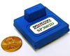 Jackson MI (SPX) Oct 22, 2008
Sparton has announced the SP3002D Digital Compass, the newest member of its next generation digital compass family. The Sparton SP3002D provides many of the enhanced performance features but at a lowered price. |
|
| The content herein, unless otherwise known to be public domain, are Copyright Space.TV Corporation. AFP and UPI Wire Stories are copyright Agence France-Presse and United Press International. ESA Portal Reports are copyright European Space Agency. All NASA sourced material is public domain. Additional copyrights may apply in whole or part to other bona fide parties. Advertising does not imply endorsement, agreement or approval of any opinions, statements or information provided by Space.TV Corp on any Web page published or hosted by Space.TV Corp. Privacy Statement |