Subscribe free to our newsletters via your
. Space Industry and Business News .


EARTH OBSERVATION
SMOS has a better look at salinity
by Staff Writers
Paris (ESA) Oct 05, 2012


The normal 10-day operation cycle of an Argo float. There are over 3500 floats in the oceans and seas. Credits: Southampton Oceanography Centre. For a larger version of this image please go here.

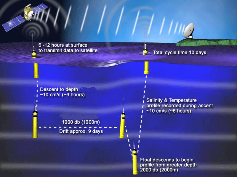
Earth observation measurements shouldn't be taken with a pinch of salt. ESA is comparing readings of sea-surface salinity from drifting floats to confirm the SMOS water mission's measurements.

Since its launch in 2009, ESA's Soil Moisture and Ocean Salinity (SMOS) satellite has been helping us to understand the water cycle. As with any Earth observation mission, it is important to validate the readings acquired from space. This involves comparing the satellite data with measurements taken directly in the water.

For SMOS, that means comparing its readings to data from floats or drifters that measure ocean salinity at different depths.

One of the major networks of in-situ drifters is Argo. The network, involving over 50 research and operational agencies in more than 30 countries, uses autonomous floats to collect temperature, salinity and deep current data.

With over 3500 active drifters, the Argo floats acquire in situ data in the upper 2000 m of the ocean.

These measurements are then directly compared to SMOS data, which in turn cover the global ocean and provide measurements of the salinity in the first centimetre of the sea surface.

SMOS provides measurements averaged over a surface of 40x40 sq km, but the difference of the size of the area measured and other influencing factors like background noise lead to differences between SMOS and Argo measurements.

"Since Argo measurements are taken much deeper than SMOS's, the stratification of the upper layer of the ocean needs to be taken into account when comparing the two salinities in rainy regions," said Jacqueline Boutin from France's Laboratory for Oceanography and Climate (LOCEAN).

"For example, rain over the ocean will cause SMOS to pick up lower salinity readings than Argo."

The advantage that SMOS has over the Argo floats is that the satellite provides a complete view of the global ocean every five days.

Argo measurements, on the other hand, provide punctual salinity data sampled at a lower resolution than SMOS every 10 days.

The higher precision provided by the Argo floats, however, complements the SMOS measurements.

.


Related Links
SMOS
Earth Observation News - Suppiliers, Technology and Application


Comment on this article via your Facebook, Yahoo, AOL, Hotmail login.

Share this article via these popular social media networks
del.icio.usdel.icio.us DiggDigg RedditReddit GoogleGoogle


EARTH OBSERVATION
Digital Map Products to Discuss the New Rules for Communicating with Residents
Irvine, CA (SPX) Oct 02, 2012
Digital Map Products (DMP) is excited to announce that it will be participating as both an exhibitor and presenter at the International City/County Management Association's (ICMA) 98th Annual Conference in Phoenix, AZ. This industry leading conference, which brings together local government decision makers who serve cities, counties, and regional entities of all sizes, will take place Octo ... read more


EARTH OBSERVATION
Google, publishers end long-running copyright case

Apple even stronger a year after Steve Jobs death

Prehistoric builders reveal trade secrets

Space debris delays Japan's satellite experiment

EARTH OBSERVATION
Raytheon to provide Joint Tactical Terminal radios with latest security features to US Navy

Northrop Grumman Awarded Contract to Extend BACN Communications Connectivity to the Tactical Edge

Hughes Awarded Custom SATCOM Solutions Contract by GSA

4 SOPS begins testing newest AEHF satellite

EARTH OBSERVATION
SpaceX craft on way to ISS in first supply run

Orbital Begins Antares Rocket Operations at Mid-Atlantic Regional Spaceport

H-IIB Launch Service Privatization

Ariane rocket launches two telecom satellites

EARTH OBSERVATION
Twin Galileo satellites fuelled and ready for launch

Northrop Grumman to Improve Performance of MEMS Inertial Sensors for DARPA

Lockheed Martin Delivers Propulsion Core for the First GPS III Satellite

China launches another 2 navigation system satellites

EARTH OBSERVATION
JAL to extend Japan-China flight cuts amid row

Lockheed Martin Announces New Solution to Reduce Airport Congestion and Improve Overall Airspace Efficiency

New Brazilian facility for Eurocopter

GE calls for jet engine checks after China incident

EARTH OBSERVATION
Visionary transparent memory a step closer to reality

Acoustic cell-sorting chip may lead to cell phone-sized medical labs

New method monitors semiconductor etching as it happens - with light

New method monitors semiconductor etching as it happens - with light

EARTH OBSERVATION
SMOS has a better look at salinity

Digital Map Products to Discuss the New Rules for Communicating with Residents

Apple CEO sorry for maps shortcomings

Landslide mapping in the Swiss Alps

EARTH OBSERVATION
Council of war gathers for world's biodiversity crisis

Mobiles phones getting less toxic: researcher

Remarkable enzyme points the way to reducing nitric acid use in industry

Solving the stink from sewers


The content herein, unless otherwise known to be public domain, are Copyright 1995-2014 - Space Media Network. AFP, UPI and IANS news wire stories are copyright Agence France-Presse, United Press International and Indo-Asia News Service. ESA Portal Reports are copyright European Space Agency. All NASA sourced material is public domain. Additional copyrights may apply in whole or part to other bona fide parties. Advertising does not imply endorsement,agreement or approval of any opinions, statements or information provided by Space Media Network on any Web page published or hosted by Space Media Network. Privacy Statement