 |
Paris, France (ESA) Nov 04, 2010 One year ago, ESA's SMOS satellite was launched to improve our knowledge of the water cycle. We are now not only closer to understanding more about Earth, but the novel technology employed by SMOS is clearly demonstrating a new way of monitoring Earth from space. The Earth Explorer Soil Moisture and Ocean Salinity (SMOS) satellite was lofted into space in the early hours of 2 November 2009 from the Plesetsk Cosmodrome in northern Russia. The next six months were spent commissioning the mission. This included calibrating the instrument to ensure that the science community receives the best-possible data on soil moisture and ocean salinity. With everything in good working order, the mission formally began operations at the end of May. Despite some problems caused by interference from radar, TV and radio transmissions, which are gradually being turned off, the mission is now delivering a wealth of data on soil moisture and sea-surface salinity. Speaking about soil moisture data, Yann Kerr from the Centre d'Etudes Spatials de la Biosphere said, "From monitoring drought and floods down to the soil conditions that lead to locust hatching, SMOS is fulfilling all our expectations and more. Further availability of the data will open up new research areas, paving the way to new successes." Jordi Font from the Institut de Ciencies del Mar at the Spanish Research Council added, "It has been a really exciting 12 months. With the excellent performance of the SMOS instrument we now have the challenge of improving the models and processes to provide more accurate data for sea-surface salinity. "Nevertheless, I am convinced that SMOS will mark a milestone in the history of ocean remote-sensing." Although there is still work to be done on refining the processing for sea-surface salinity, the first global map combining both soil moisture and ocean salinity data has recently been produced. Nicolas Reul from Ifremer said, "One year after launch the ocean salinity data are very promising. However, we still have a little way to go to filter and understand the signals in order to reach the measurement goal of 0.1-0.2 practical salinity units." SMOS carries an innovative interferometic radiometer that operates in the L-band microwave range to capture images of 'brightness temperature' which are used to produce global maps of soil moisture and ocean salinity. By consistently mapping these two variables, SMOS will not only advance our understanding of the exchange processes between Earth's surface and atmosphere, but will also help to improve weather and climate models. Patricia de Rosnay from the European Centre for Medium-Range Weather Forecasts (ECMWF) commented, "So far, SMOS has been providing an enormous amount of data and information on land and ocean surfaces. "Integrating these observations in ECMWF's Integrated Forecasting System has been challenging, but will eventually increase our understanding of land-surface processes and is expected to result in better weather forecasts." As scientists and engineers celebrate the mission's achievements over the past 12 months they also look to the future, assured that the coming months will bring more success. Happy first birthday SMOS!
Share This Article With Planet Earth
Related Links SMOS at ESA IFREMER Instituto De Ciencias ECMWF Water News - Science, Technology and Politics
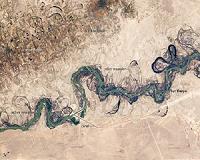 Syr Darya River Floodplain, Kazakhstan, Central Asia
Greenbelt MD (SPX) Nov 04, 2010 Central Asia's most important cotton-growing region is concentrated in the floodplain of the Syr Darya. The river was one of the farthest points reached by the ancient Greek leader Alexander of Macedon (or Alexander the Great). The floodplain is shown here as a tangle of twisting meanders and loops (image center). The darkest areas are brushy vegetation along the present course (filled wit ... read more |
|
| The content herein, unless otherwise known to be public domain, are Copyright 1995-2010 - SpaceDaily. AFP and UPI Wire Stories are copyright Agence France-Presse and United Press International. ESA Portal Reports are copyright European Space Agency. All NASA sourced material is public domain. Additional copyrights may apply in whole or part to other bona fide parties. Advertising does not imply endorsement,agreement or approval of any opinions, statements or information provided by SpaceDaily on any Web page published or hosted by SpaceDaily. Privacy Statement |


 del.icio.us
 Digg
Digg Reddit
 YahooMyWeb
 Google