 |
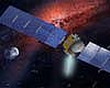
Paris, France (ESA) Aug 05, 2008 On 4 August Rosetta starts to use its cameras to visually track asteroid Steins. These observations will be used to refine the trajectory of the spacecraft relative to Steins and to adjust it, if necessary, to achieve the desired fly-by conditions: 800 km distance at closest approach on 5 September at 18:37 UTC and zero phase angle reached prior to closest approach. The campaign begins when the spacecraft is at a distance of 24 million km from Steins and continues until 4 September at which time Rosetta will be at 950,000 km from the asteroid. Currently the asteroid's orbit is known, from ground-based measurements, to an accuracy of about 100 km. With data from the navigation campaign it may be possible to reduce this to a few km (in the direction perpendicular to the flight direction of the asteroid). Data obtained after the navigation campaign, during the fly-by proper, will improve knowledge of the along track position to the same degree.
Images from OSIRIS and Navcam point the way For the first 3 weeks of the campaign 2 slots per week have been made available. During this period only OSIRIS can detect the asteroid since it is still too far away to be visible to the Navcams. From August 25 one slot per day is assigned to the optical navigation campaign. At this stage, and for the remainder of the navigation campaign, the two navigation cameras will also start to track the asteroid. The acquired images are stored on-board the spacecraft and are transmitted to the ground-stations during the next available pass. The data is then transferred to the Rosetta Mission Operations Centre (RMOC) telemetry archive. Navcam data are retrieved from the archive by the RMOC/Flight Dynamics System and are converted into raw images. The OSIRIS data are retrieved by members of the OSIRIS team at the 'Max Planck Institut fuer Sonnensystemforschung' (MPS) and converted into raw images which are then made available to the Flight Dynamics System. Both sets of raw data are processed in order to identify Steins and to determine accurately the inertial direction from the spacecraft to the asteroid based on the stellar background around the asteroid.
Determining the best flight path Preparations for the trajectory correction manoeuvres are performed according to the following processing cycle: + Optical measurements: As described above several images are acquired by the NAVCAM and OSIRIS cameras. These are processed on ground to determine the direction of the spacecraft to asteroid. + Orbit determination: The estimated orbits of the spacecraft and the asteroid are improved based on the optical measurements and radiometric data. (The latter is obtained routinely to determine the position of the spacecraft.) + Manoeuvre optimisation: The size and direction of the required manoeuvres to correct the orbit are determined. + Command generation: The final step is to generate the spacecraft commands to perform the required manoeuvres. These commands are sent to the spacecraft to be executed. + Challenging and demanding timeline The turn-around time for a full processing cycle for a manoeuvre becomes shorter and more demanding the nearer to closest approach it is executed. Manoeuvres will be executed only if orbit corrections are necessary. Since the optical measurements become more accurate as the spacecraft approaches Steins it is quite likely that most, if not all, manoeuvres will be required. The optical navigation campaign has been devised to ensure the best possible fly-by conditions for Rosetta as it approaches one of the key scientific targets of its 10 year mission. Related Links Rosetta Asteroid and Comet Mission News, Science and Technology
 Los Angeles CA (SPX) Jul 31, 2008
Dawn continues its flight through the solar system with all systems functioning well. |
|
| The content herein, unless otherwise known to be public domain, are Copyright Space.TV Corporation. AFP and UPI Wire Stories are copyright Agence France-Presse and United Press International. ESA Portal Reports are copyright European Space Agency. All NASA sourced material is public domain. Additional copyrights may apply in whole or part to other bona fide parties. Advertising does not imply endorsement, agreement or approval of any opinions, statements or information provided by Space.TV Corp on any Web page published or hosted by Space.TV Corp. Privacy Statement |

