|
Pasadena CA (JPL) Apr 16, 2007 After studying Mars four times as long as originally planned, NASA's Mars Global Surveyor orbiter appears to have succumbed to battery failure caused by a complex sequence of events involving the onboard computer memory and ground commands. The causes were released today in a preliminary report by an internal review board. The board was formed to look more in-depth into why NASA's Mars Global Surveyor went silent in November 2006 and recommend any processes or procedures that could increase safety for other spacecraft. Mars Global Surveyor last communicated with Earth on Nov. 2, 2006. Within 11 hours, depleted batteries likely left the spacecraft unable to control its orientation. "The loss of the spacecraft was the result of a series of events linked to a computer error made five months before the likely battery failure," said board Chairperson Dolly Perkins, deputy director-technical of NASA Goddard Space Flight Center, Greenbelt, Md. On Nov. 2, after the spacecraft was ordered to perform a routine adjustment of its solar panels, the spacecraft reported a series of alarms, but indicated that it had stabilized. That was its final transmission. Subsequently, the spacecraft reoriented to an angle that exposed one of two batteries carried on the spacecraft to direct sunlight. This caused the battery to overheat and ultimately led to the depletion of both batteries. Incorrect antenna pointing prevented the orbiter from telling controllers its status, and its programmed safety response did not include making sure the spacecraft orientation was thermally safe. The board also concluded that the Mars Global Surveyor team followed existing procedures, but that procedures were insufficient to catch the errors that occurred. The board is finalizing recommendations to apply to other missions, such as conducting more thorough reviews of all non-routine changes to stored data before they are uploaded and to evaluate spacecraft contingency modes for risks of overheating. "We are making an end-to-end review of all our missions to be sure that we apply the lessons learned from Mars Global Surveyor to all our ongoing missions," said Fuk Li, Mars Exploration Program manager at NASA's Jet Propulsion Laboratory, Pasadena, Calif.
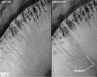
Mars Global Surveyor Mission Highlights A few of the mission's many important discoveries about Mars include: + Before-and-after images revealing bright new deposits in two gullies on Mars suggest liquid water has carried sediment down them in the past seven years. These pictures from the spacecraft's camera are the strongest evidence to date that water still flows occasionally on the surface of Mars, in brief episodes. + The mineral-mapping infrared spectrometer found concentrations of a mineral that often forms under wet conditions, fine-grained hematite. This discovery led to selection of a hematite-rich region as the landing site for NASA's Mars Exploration Rover Opportunity. + Laser altimeter measurements have produced an unprecedented global topographic map of Mars. The instrument revealed a multitude of highly eroded or buried craters too subtle for previous observation, and mapped canyons within the polar ice caps. + The magnetometer found localized remnant magnetic fields, indicating that Mars once had a global magnetic field like Earth's, shielding the surface from deadly cosmic rays. + Before-and-after images identified 20 new impact craters in 2006 that had not been present seven years earlier. These observations allowed calibrating calculations that are widely used for estimating the ages of planetary surfaces from crater densities. + The camera found a fan-shaped area of interweaving, curved ridges interpreted as evidence of an ancient river delta resulting from persistent flow of water over an extended period in the planet's ancient past. + Its long life also allowed Mars Global Surveyor to track changes through repeated annual cycles. For three Martian summers in a row, deposits of carbon dioxide ice near Mars' south pole shrunk from the previous year's size, suggesting a climate change in progress. Related Links MGS at JPL Mars News and Information at MarsDaily.com Mars News and Information at MarsDaily.com Lunar Dreams and more
 Pasadena CA (SPX) Jan 11, 2007
NASA has formed an internal review board to look more in-depth into why NASA's Mars Global Surveyor went silent in November 2006 and recommend any processes or procedures that could increase safety for other spacecraft. |
|
| The content herein, unless otherwise known to be public domain, are Copyright Space.TV Corporation. AFP and UPI Wire Stories are copyright Agence France-Presse and United Press International. ESA Portal Reports are copyright European Space Agency. All NASA sourced material is public domain. Additional copyrights may apply in whole or part to other bona fide parties. Advertising does not imply endorsement, agreement or approval of any opinions, statements or information provided by Space.TV Corp on any Web page published or hosted by Space.TV Corp. Privacy Statement |