|
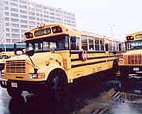
Seattle WA (SPX) Mar 19, 2008 Seattle-based Zonar Systems said it is providing RFID technology to the school bus industry to answer the iconic 1969-television question, "It's 10 p.m. Do you know where your children are?" The company's patented ZPass system identifies when and where a student enters or exits the school bus to enhance their safety and security. According to Zonar's SVP of Marketing, Bill Brinton, "Safety, security and accountability are fundamental expectations when children ride school buses. The industry record is already stellar. But RFID technology now makes the job easier and gives school bus operators, school officials and parents the peace of mind that comes from knowing where their children are while making their trip to and from school." "Following events of 9/11 the school bus industry audited its safety and security efforts, and technology solutions are being embraced because of their accuracy and reliability. In the world we live in today, parents understandably want and deserve this peace of mind," Brinton said. Brinton explained that the ZPass system works without the need for a student to do anything. They are issued a unique RFID card that can be kept anywhere on their person, such as in a backpack, purse or wallet-it need not be visible. As the student passes the card reader upon entering or exiting the bus, the time, date, and location are logged and transmitted to a secure database. The school system can then access the information from any web browser using Zonar's Ground Traffic Control application. ZPass integrates with Zonar's HD-GPS technology that is already implemented on school buses throughout the country. This one-of-a-kind system captures data in four dimensions including latitude, longitude, time, and speed at every data collection point, giving administrators a clear view of the bus' path, each stop and start, and even a time, date, and location at which the door is opened. This creates certainty for school officials and parents, as well as accountability for the drivers. John Harris, Transportation Supervisor for the Quincy, WA school system said, "It's all about the safety of the children entrusted to our care. We are installing it now in our buses and the initial experience has been good. It builds extra confidence and parents like it." Ray Trejo, Director of Transportation for the Demming, NM public schools said, "ZPass complements the security that already exists inside the school building by making sure we know where students are from the time they are picked up at their bus stop until they are dropped off at the end of the school day." "I want to emphasize the built in privacy safeguards in ZPass," Brinton said. "Student location is monitored solely when riding school buses. The entire process is secure, no personal information about the student is included on the card, and all personal data is confined to and controlled by the school system." Mike Martin, Executive Director of the National Association for Pupil Transportation (NAPT), the industry's largest trade group, acknowledged that some have raised concerns about student privacy, but echoed Brinton's comments about how the information is safeguarded. "Accountability, safety and security are the cornerstones of what we do every school day. 'We don't know where a bus is, or where your child is' are unacceptable answers in our industry, and we know most parents agree." Zonar also markets to the school bus industry and others a popular RFID- based system that verifies the vehicle has been thoroughly inspected before and after every trip. The driver uses a hand-held RFID reader and companion "tags" placed around and inside the bus to electronically document their observations. The inspection information is uploaded wirelessly and any safety, security, or mechanical problems are addressed promptly. Related Links GPS Applications, Technology and Suppliers
 Los Angeles AFB (SPX) Mar 19, 2008
The Global Positioning Systems Wing, Air Force Space Command, Department of Transportation, and the Los Angeles Chapter of the Armed Forces Communications and Electronics Association (AFCEA) have re-established the GPS Partnership Council as the premier annual event for GPS stakeholders to exchange the latest GPS information and status, view the latest industry exhibits and capabilities, network and enhance the overall GPS vision. |
|
| The content herein, unless otherwise known to be public domain, are Copyright Space.TV Corporation. AFP and UPI Wire Stories are copyright Agence France-Presse and United Press International. ESA Portal Reports are copyright European Space Agency. All NASA sourced material is public domain. Additional copyrights may apply in whole or part to other bona fide parties. Advertising does not imply endorsement, agreement or approval of any opinions, statements or information provided by Space.TV Corp on any Web page published or hosted by Space.TV Corp. Privacy Statement |