|
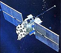
Moscow (RIA Novosti) May 21, 2007 Russian President Vladimir Putin signed Friday a decree on the Glonass navigation system to provide the service free for customers, the Kremlin press service said. Glonass is a Russian version of the U.S. Global Positioning System (GPS), which is designed for both military and civilian use, and allows users to identify their positions in real time. The system can also be used in geological prospecting. "Access to civilian navigation signals of global navigation satellite system Glonass is provided to Russian and foreign consumers free of charge and without limitations," the presidential decree reads. In line with the decree, satellite navigation equipment bought for federal bodies of executive power and organizations subordinate to them should operate using Glonass signals. Putin charged the Federal Space Agency with coordinating work to maintain, develop and use the system for civilian and commercial needs. The head of the space agency said in April Russia will bring the number of satellites comprising its Glonass navigation system to 18 by the end of 2007. Anatoly Perminov said then a full orbital group of 24 satellites will be ready for global coverage by the end of 2009, but even with 18 satellites in orbit it will be able to start providing services for military and civilian users, covering Russian territory. A total of $380 million has been appropriated for Glonass from the federal budget in 2007, and $181 million in 2006. The space agency head also said that Glonass will be fully integrated with the U.S. GPS and European Galileo satellite navigation systems. "We will ensure the compatibility and complimentary use of the Russian Glonass system with the American GPS, and later with the European Galileo systems," he said. The first launch under the Glonass program took place October 12, 1982, but the system was only formally launched September 24, 1993. The satellites currently in use are of two modifications - Glonass and its updated version Glonass-M. The latter has a longer service life of seven years and is equipped with updated antenna feeder systems and an additional navigation frequency for civilian users. A future modification, Glonass-K, is an entirely new model based on a non-pressurized platform, standardized to the specifications of the previous models' platform, Express-1000. Glonass-Ks' estimated service life has been increased to 10-12 years, and a third, "civilian" L-range frequency has been added.
Source: RIA Novosti Related Links Glonass GPS Applications, Technology and Suppliers
 Paris, France (ESA) May 11, 2007
Travellers have relied on accurate timekeeping for navigation since the development of the marine chronometer in the eighteenth century. Galileo, Europe's twenty-first century navigation system, also relies on clocks - but they are millions of times more accurate than those earlier timepieces. |
|
| The content herein, unless otherwise known to be public domain, are Copyright Space.TV Corporation. AFP and UPI Wire Stories are copyright Agence France-Presse and United Press International. ESA Portal Reports are copyright European Space Agency. All NASA sourced material is public domain. Additional copyrights may apply in whole or part to other bona fide parties. Advertising does not imply endorsement, agreement or approval of any opinions, statements or information provided by Space.TV Corp on any Web page published or hosted by Space.TV Corp. Privacy Statement |