|
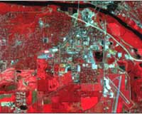
West Lafayette IN (SPX) Jan 14, 2009 A facility modeled after Purdue University's Terrestrial Observatory that will be used to provide early warning and mitigate the effects of disasters such as epidemics, famine and flooding will be built in Egypt as part of a NATO-funded effort. NATO is funding the project through its Science for Peace and Security program, which creates partnerships among alliance countries and Eastern European or so-called Mediterranean Dialogue nations-a forum of cooperation between seven countries centered in North Africa. The program promotes understanding and advances education and science, said Gilbert Rochon, Information Technology at Purdue (ITaP) associate vice president for collaborative research. It also aims to yield practical results, in this case to provide meteorological and environmental data to countries within the region with the help of a powerful Geographic Information System. Development of the Kamal Ewida Earth Observatory is being supported this year by about $78,000 from NATO. The project will receive another $315,000 in NATO funding over the next three years. Magdy Abdel Wahab, chair of the meteorology and astronomy department at Cairo University, will be the partner-country director. Purdue's long experience with collecting, archiving and interpreting high-resolution satellite and other remotely sensed data made for a good model, said Rochon, who heads the Purdue Terrestrial Observatory and will serve as NATO-country project director. The project will largely recreate the Purdue Terrestrial Observatory, part of Purdue's Rosen Center for Advanced Computing, and its remote sensing and analysis capabilities in Cairo, Egypt, to help identify and track natural and human-caused disasters. In cases like earthquakes and terrorism, it might be used to assess vulnerability and assist postdisaster reconstruction. For example, the information generated could help in planning for restoring power or repairing buildings after a quake, said Rochon. He is working with Purdue colleague Okan Ersoy, along with Gamal El Afandi at Al Azhar University in Cairo and Gulay Atlay at Bogazi�i University's Kandilli Observatory and Earthquake Research Institute in Istanbul, Turkey, in addition to Wahab. Ersoy is a Purdue electrical and computer engineering professor. Part of his research focuses on remote sensing and applying machine learning and image processing techniques to get computers to analyze such data autonomously. Using high-performance computing like that available through the Rosen Center, the system could provide nearly real-time interpretation of data and help the region react to disasters quickly, Ersoy said. Rochon, chief scientist for the Rosen Center, said the system also might be useful for sustainable development efforts, identifying from a vantage point in space, for instance, the spread of crop-damaging locusts and helping to better focus efforts to halt it in an environmentally friendly manner. Ersoy said the project fits with the university's global education efforts. He also said it is just a good thing to do. "We consider it a noble project," Ersoy said. "These problems are increasing in scope." The Purdue Terrestrial Observatory gathers masses of satellite, radar and other remote-sensing data, as well as information collected on the ground. The observatory assists researchers on campus and internationally in an interdisciplinary array of fields who mine remote-sensing data and work to develop techniques for employing remote sensing in early detection and mitigation of disasters. The center also makes data available to researchers and decision-makers from the local to national levels, and the agricultural sector, to use in Geographic Information Systems. Related Links Purdue Terrestrial Observatory Bringing Order To A World Of Disasters A world of storm and tempest When the Earth Quakes
 Madison WI (SPX) Jan 11, 2009
Economists use leading indicators - the drivers of economic performance - to take the temperature of the economy and predict the future. Now, in a new study, scientists take a page from the social science handbook and use leading indicators of the environment to presage the potential collapse of ecosystems. |
|
| The content herein, unless otherwise known to be public domain, are Copyright Space.TV Corporation. AFP and UPI Wire Stories are copyright Agence France-Presse and United Press International. ESA Portal Reports are copyright European Space Agency. All NASA sourced material is public domain. Additional copyrights may apply in whole or part to other bona fide parties. Advertising does not imply endorsement, agreement or approval of any opinions, statements or information provided by Space.TV Corp on any Web page published or hosted by Space.TV Corp. Privacy Statement |