|
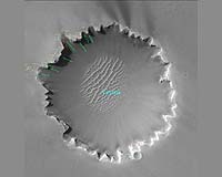
Pasadena CA (JPL) Jan 30, 2007 After driving around the "Bay of Toil" onto "Cape Desire," a promontory overlooking "Victoria Crater," Opportunity began testing various techniques for visually determining the rover's precise location after moving across sandy, somewhat slippery terrain. Because the sandy surface is largely flat and featureless (except for the dropoff into "Victoria Crater"), the rover's primary reference points are the long rows of repeating ridges and holes in its own tracks. They all look pretty much the same, repeating the same pattern every 80 centimeters (2.6 feet). The rover is working on ways to make its tracks look different at every step, which will remove any ambiguities in the images of the tracks. Opportunity continued to test new computer smarts to enable automated placement of instruments on a target of scientific interest.
Sol-by-sol summary In addition to daily observations that included measuring atmospheric dust with the panoramic camera, searching for clouds with the navigation camera, surveying the sky and ground with the miniature thermal emission spectrometer, and imaging the sky with the panoramic camera, Opportunity completed the following activities: Sol 1063 (Jan. 19, 2007): Opportunity measured atmospheric argon with the alpha-particle X-ray spectrometer and acquired part of a panoramic postcard of Victoria Crater using the panoramic camera. Opportunity surveyed rock targets known as "Gomes," "Gomes Background" (the surface area around Gomes), "Santandres," "Deseado," "Narrows," "Sardines," and "Trabajo" using the miniature thermal emission spectrometer. Sol 1064: Opportunity drove 4.21 meters (13.8 feet) around the Bay of Toil toward Cape Desire. The drive included a test to allow the rover to make unique track patterns for better determination of its position. The drive test had two legs: one in which the rover dragged the right front wheel for 5 centimeters (2 inches) and then drove on all 6 wheels for 55 centimeters (1.8 feet), and a second in which the rover drove 60 centimeters (24 inches) and then spun both front wheels 23 degrees, or approximately 5 centimeters (2 inches). Sol 1065: Opportunity acquired a full-color image using all 13 filters of the panoramic camera of the foreground area, then surveyed the foreground with the miniature thermal emission spectrometer. The rover monitored dust on the mast and acquired panoramic camera images of the sky at sunset. Sol 1066: Opportunity drove 25.38 meters (83.27 feet) away from the rim of Victoria Crater to continue testing and determining the best method for visual odometry -- determining the precise position by imaging the rover's tracks. The rover did a series of 5 tests, each covering 5 centimeters (2 inches) and each designed to produce a different pattern in the tracks. All of the driving was backward. During the first test, the rover created scuffs with both front wheels. During the second test, the rover wiggled the left wheel and scuffed with the right wheel. The third test was a "drunken sailor" test in which the rover drove in small curves. During the fourth test, the rover turned in place 10 degrees at specific intervals, or "steps." The fifth test was a combination of the previous four tests. Sol 1067: Opportunity drove 40.43 meters (132.6 feet) to set up for the approach to the edge of Cape Desire. The rover acquired panoramic camera images of "Guam," a chevron-shaped rock outcrop. Sol 1068: Opportunity drove backward 7.8 meters (26 feet) toward the tip of Cape Desire. Sol 1069 (Jan. 26, 2007): Plans called for Opportunity to drive a short distance of 7 meters (23 feet) to an imaging position about 2.5 meters (8.2 feet) away from the left edge of Cape Desire. From this vantage point, Opportunity was to acquire images of "Bahia Blanca," the next bay to the north. The rover was also slated to survey the horizon with the panoramic camera and complete Step 4 of the automatic placement test, the first attempt at actually reaching and touching a target autonomously. During the test, the rover was to acquire images with the hazard avoidance camera, swing back the robotic arm, touch the target with the Moessbauer spectrometer, and acquire microscopic images. Odometry: As of sol 1068 (Jan. 25, 2007), Opportunity's total odometry was 9,918 meters (6.2 miles). Related Links Mars Rovers at JPL Mars Rovers at Cornell Mars News and Information at MarsDaily.com Mars News and Information at MarsDaily.com Lunar Dreams and more
 Pasadena CA (JPL) Jan 31, 2007
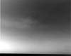
NASA's Mars Exploration Rover Opportunity captured a view of wispy afternoon clouds, not unlike fair weather clouds on Earth, passing overhead on the rover's 956th sol, or Martian day (Oct. 2, 2006). With Opportunity facing northeast, the clouds appear to drift gently toward the west in this movie taken with the rover's navigation camera. The 10 frames, taken 32 seconds apart, show the formation and evolution of what are likely mid-level, convective water clouds. |
|
| The content herein, unless otherwise known to be public domain, are Copyright Space.TV Corporation. AFP and UPI Wire Stories are copyright Agence France-Presse and United Press International. ESA Portal Reports are copyright European Space Agency. All NASA sourced material is public domain. Additional copyrights may apply in whole or part to other bona fide parties. Advertising does not imply endorsement, agreement or approval of any opinions, statements or information provided by Space.TV Corp on any Web page published or hosted by Space.TV Corp. Privacy Statement |