 |
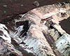
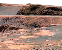
Pasadena CA (JPL) Mar 20, 2007 Opportunity is healthy and is positioning itself for long baseline stereo imaging of "Cape St. Vincent," across the "Valley Without Peril." Subsequently, the rover will drive northeast to the mouth of the Valley Without Peril for long baseline stereo imaging of the valley floor. On sol 1112 Opportunity performed another test of RAT (rock abrasion tool) grind operations. The test indicated the need to circumvent a portion of the flight software which is still trying to use the RAT's failed encoder. The "patch" will be up-linked and tested this weekend. On sol 1114 Opportunity attempted an 8-meter (26 feet) drive to a position on the west bank of the Valley Without Peril in order to image Cape St. Vincent to the east. The drive stopped after only a half a meter of progress because the rover failed to stay within limits placed on its heading by the rover drivers. A similar drive is planned for sol 1116. Sol-by-sol summary: In addition to Opportunity's daily science observations, which include a panoramic camera tau measurement and miniature thermal emission spectrometer sky and ground stares, the rover did the following: Sol 1112 (March 11, 2007): On this sol, Opportunity conducted another RAT grind test, miniature thermal emission spectrometer 7-point sky and ground stares, panoramic camera high sun observation, an alpha particle X-ray spectrometer integration to look for Argon and panoramic camera sky thumbnail images. Sol 1113: Opportunity used the instruments on its "head" (or panoramic camera mast assembly) to scan the sky and then used the panoramic camera to image the local foreground in 13-filters. The navigation camera was then used to prepare for miniature thermal emission spectrometer observations and to look for clouds. Sol 1114: The rover began to drive south-southwest to the imaging position for Cape St. Vincent. The drive stalled due to Opportunity exceeding heading limitations set by rover drivers. A post-drive navigation camera image was shot for next drive. Sol 1115: On this sol, Opportunity completed miniature thermal emission spectrometer sky and ground stares, navigation camera search for clouds, panoramic camera sky thumbnail images and panoramic camera mast assembly dust monitoring. Sol 1116: Opportunity drove south-southwest to the imaging position for Cape St. Vincent and then completed a post-drive navigation camera mosaic for the next drive. Sol 1117: On this sol, Opportunity calibrated the miniature thermal emission spectrometer and then used it to assess the local sky and ground. The navigation camera was used to look for clouds. As of sol 1114, Opportunity's total odometry is 10,285.53 meters (6.39 miles). Related Links Mars News and Information at MarsDaily.com Mars News and Information at MarsDaily.com Lunar Dreams and more
 Pasadena CA (JPL) Mar 15, 2007
Some bright Martian soil containing lots of sulfur and a trace of water intrigues researchers who are studying information provided by NASA's Spirit rover. |
|
| The content herein, unless otherwise known to be public domain, are Copyright Space.TV Corporation. AFP and UPI Wire Stories are copyright Agence France-Presse and United Press International. ESA Portal Reports are copyright European Space Agency. All NASA sourced material is public domain. Additional copyrights may apply in whole or part to other bona fide parties. Advertising does not imply endorsement, agreement or approval of any opinions, statements or information provided by Space.TV Corp on any Web page published or hosted by Space.TV Corp. Privacy Statement |
