|
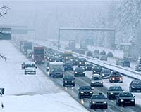
Palo Alto CA (SPX) Feb 12, 2008 Nokia and UC Berkeley researchers have tested technology that could soon transform the way drivers navigate through congested highways and obtain information about road conditions. One hundred cars equipped with the GPS-enabled Nokia N95, and driven by students from the University of California, traveled a 10-mile stretch of highway near San Francisco to show how real-time traffic information can be collected from the GPS feed, while preserving the privacy of the devices' owners. The experiment was carried out to test the traffic data collection and aggregation system, while studying the trade-offs between data accuracy, personal privacy, and data collection costs. The software aggregating the GPS feeds immediately disassociates that data from an individual device and combines it with the general stream of traffic data. To protect privacy, all data is anonymous and aggregated, and protected by banking-grade encryption During the experiment, special software on the mobile devices periodically sent anonymous speed and location readings from the integrated GPS to servers. The feeds were then combined to create a real-time picture of traffic speeds and projected travel times. "Mobile device users control the service. If an individual does not want their device to transmit position data they turn off the feed from their GPS," stated Quinn Jacobson, Research Leader at Nokia Research Center, Palo Alto. "Nokia is very excited at the potential for this system to revolutionize travel planning, carrying on from the Nokia Maps navigation service available on certain Nokia devices," continued Jacobson. "Integration of traffic information with functions such as calendar and online timetables may one day mean the mobile device can act as personal travel planner." "There are mobile device-based systems out there that can collect data in a variety of ways, such as measuring signal strength from towers and triangulating position, but to our knowledge, this is the first demonstration of this scale using GPS-enabled mobile devices to provide traffic related data such as travel times, and with a deliberate focus on critical deployment factors like bandwidth costs and personal privacy issues," said Director Thomas West, director, UC Berkeley's California Center for Innovative Transportation. The researchers believe that fewer than 5% of drivers need to contribute location data for the system to be effective on any particular highway. For state transportation agencies such as The California Department of Transport (Caltrans), tapping into the vast network of mobile phones on the road could one day remove the need to invest in expensive infrastructure to obtain traffic information as well as greatly expanding the coverage of such services. In the USA alone congestion causes 4.2 billion hours extra travel every year and the purchase of extra 2.9 billion gallons of fuel for a congestion cost of USD 78 billion. With the number of vehicles on the road increasing rapidly around the world a cost-effective method of travel planning could help drivers make smarter decisions about which routes to take, the researchers say. The project brings together research teams from the Nokia Research Center (NRC) in Palo Alto and from UC Berkeley, interacting through UC Berkeley's California Center for Innovative Transportation (CCIT). These teams are developing the algorithms, software and architecture of this GPS-based traffic monitoring system. The project is supported by a USD 186,000 grant from Caltrans. Additional support comes from the National Science Foundation, Nokia, Tekes, Rutgers University's WINLAB, the University of California Transportation Center and the Volvo Center of Excellence for Future Urban Transport at UC Berkeley's Institute of Transportation Studies. Related Links Nokia Research Center GPS Applications, Technology and Suppliers
 London, UK (SPX) Feb 11, 2008
Presently, most handsets with integrated GPS are smartphones or high-end feature phones, with wholesale prices in the range of $250 to $500. However, chipset manufacturers now have solutions in place that will permit the integration of GPS in handsets at lower costs, and provide significant improvements in terms of accuracy, time-to-first-fix, and reception in indoor environments. As a result, the wholesale ASP (Average Selling Price) of GPS-enabled handsets will fall under $200 by 2010. |
|
| The content herein, unless otherwise known to be public domain, are Copyright Space.TV Corporation. AFP and UPI Wire Stories are copyright Agence France-Presse and United Press International. ESA Portal Reports are copyright European Space Agency. All NASA sourced material is public domain. Additional copyrights may apply in whole or part to other bona fide parties. Advertising does not imply endorsement, agreement or approval of any opinions, statements or information provided by Space.TV Corp on any Web page published or hosted by Space.TV Corp. Privacy Statement |